Maps : Meaning and Types — Geography STD 11 Arts — Question
Gujarat BoardEnglish MediumSTD 11 ArtsGeographyMaps : Meaning and Types3 Marks
Question
Explain the graphical scale.
✓
Answer
In this method, a scale or line is drawn for the map.
Such a scale is used to measure the distance between any two places.
Similarly, this method is called linear scale as the given scale is used for the map.
Although this method is simple, it is also a bit complicated, so it is less used.
The scale we use is shown in centimeters or inches, while the scale is written as interpolating units of land such as meters or flanges or miles.
In this method, the distance to the ground can be measured directly or a readable scale is drawn on one of the parts of the map.
The scale represented by drawing in this way is called graphical scale.
It is also called a linear scale as the line is used to represent the scale. Usually a measurement of the required length is drawn in one of the following parts of the map.
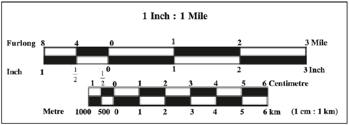
The small size map shows the scale on only $1 \ cm$ or $1$ inch in length.
This scale shows the main sections of the scale from zero to the right.
The required subdivisions of the main section are provided on the left.
Which shows the distance of a small unit like meter or flag etc.
This detail will be clearer from the figure below.
Need a full question paper?
Generate a complete, print-ready paper with questions like this in minutes — across 16+ boards, with answer keys.