Question
What are the different types of Soil according to their Zones?

Need a full question paper?

Generate a complete, print-ready paper with questions like this in minutes — across 16+ boards, with answer keys.

Start Generating Free

Similar questions

On the map of India,
(a) Mark and name the Shiwalik Range.
(b) Mark and name, the Western Ghats with two gaps, Bhor Ghat and Palghat Gap.
(c) Mark and name the peak on the Karakoram Mts, (Mt. Godwin Austien or Mt. K2).
(d) Mark and name, the highest peak on the Himalayas, (Mt Everest).
(e) Mark and name Mt. Kanchenjunga.
(f) Mark and name the Maikal Range.
(g) Shade and name the Indo-Gangetic Plain.
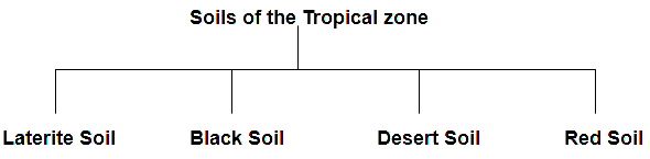
Study the extract of the Survey of India Map Sheet No. 45D/7 and answer the following questions:
(a) Give the six-figure grid reference of:
(i) ∆ 225 (ii) A lined well near Ganguwada.
(b) Name the most important perennial source of irrigation shown on the map extract.
(c) (i) What does 3r in the grid square 8895 mean?
(ii) What do you mean by 20r in the grid square 8994?
(d) Give two points in evidence to show that the region in the map extract has seasonal rainfall.
(e) (i) What does the blue line in the Varkanala indicate?
(ii) What is the general direction of the Varkanala?
(f) (i) What is the meaning of 1 : 50000 printed below the map extract?
(ii) Calculate the distance in km., along the cart track between Jegal in the grid square 8590 and Odhava in the grid square 8892.(g) Which part of the map is more developed in agricultural occupation? Give a reason for your answer.
(h) Give the four-figure grid reference of confluence of Sipu river and Varkanala.
(i) Name two types of vegetation in the given map extract.
(j) What is the pattern of drainage in the grid square 8599?
(k) (i) How many types of tracks are shown in the map extract? Name them.
(ii) What is the common mode of transportation in the southern part of this map?
(l) What is the general pattern of settlement? Why?
Name the states producing sugar and name the chief centres in each state.
###
Name four sugar milling centres in the northern plains.
Study the extract of the Survey of India Map Sheet No. 45 D/7 (A and B) and answer the following questions.
(a) Give the six figure grid reference of
(i) ∆ 277 (→) (ii) Lime kiln near Rampura (→) (iii) Stony waste (→).(b) (i) What does the blue line in the Sipu river indicate?
(ii) In which village do you see the nodal function 7 What do you mean by this?
(c) (i) What does the black lines along the streams in the grid square 9199 indicate?
(ii) How are these features formed?
(iii) What type of region is shown in grid square 8696?
(d) Give the six-figure grid reference of the following:
(i) Lime Kiln near village Panswala.
(ii) Well with water near village Gonodara.
(iii) Dry tank near village Mohudi Moti.
(e) (i) What is the direction of the flow of Sipu river?
(ii) State why does it flow in this particular direction?
(f) Mention three natural features in the grid square 8998.
(g) 
(i) What is the meaning of the term open scrub printed on the map.
(ii) How do you get an idea of the general nature of the slope in this area?
What, has been the influence of the Northern Mountain Wall on the Indian Sub-continent?
What is incineration? Give advantage and disadvantage of incineration.
Name four advantages and three disadvantages of Railways?
Study the extract of the Survey of India Map sheet No. 45D/10 and answer the following questions:
(a) 
(i) Give the four figure grid reference of the settlement of Hamirpura.
(ii) Give the six figure grid reference of the temple in the settlement of Jolpur.
(b) 
(i) What does the blue coloured circle in the grid square 0619 represent?
(ii) What is the compass direction of Dantrai from Jolpur?
(c) What is the difference between the:
(i) Pattern of settlements in 0725 and the settlement of Idarla?
(ii) Drainage pattern of the streams in 0624 and those in 0824?
(d) 
(i) What is the value of the contour line in square 0226?
(ii) What is the contour interval in the map?
(e) Mention any two factors which provide evidence that the region in the map extract is a rural region.
(f) 
(i) How does the feature, indicated by the black curves in 0721, show that rainfall in this region is seasonal?
(ii) Mention one man-made feature in the map which also provides evidence that the rainfall is seasonal.
(g)
(i) Name two natural features in 0527.
(ii) Name two manmade features in 0325.
(h) Name two features which make Dantrai a more important settlement than the other settlements in the map extract.
(i) Calculate the area of the region which lies to the south of northing 21 in square kilometres.
(j)  What are the following?
(i) The black vertical line between eastings 09 and 10.
(ii) 302 in grid square 0425.
Name the Current Expressways.
In the context of the Indian agriculture, answer the following:
How has the consolidation of land holdings helped the farming community?