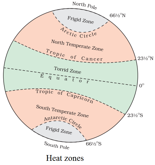
Questions

[5 marks Questions]

Take a timed test

13 questions · self-marked practice — reveal the answer and mark yourself.

Question 15 Marks
Explain major features of meridians.
Answer
The following are the major features of meridians:
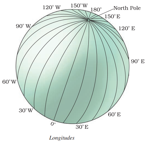
  1. Meridians are equal in length.
  2. The longitude running through the Greenwich pear London was first chosen as the Prime Meridian (Prime Meridian means chief or main meridian) having noon at the same time at all places on this line.
  3. It is the 0° longitude.
  4. It divides the earth into eastern and western hemispheres.
  5. They are semicircles.
  6. They are 360 in all -180 in the East and 180 in the West of Prime Meridian. 180°E and 180° W is one longitude.
View full question & answer
Question 25 Marks
Describe major heat zones of the Earth.
Answer
Heat Zones of the Earth.
  1. Torrid Zone:
  1. Torrid means hot.
  2. This zone receives the maximum amount of heat throughout the year, because the rays of the Sun fall vertically on this zone.
  3. This zone is located between the Tropic of Cancer $(23\frac{1}{2}^\circ \text{N})$and the Tropic of Capricorn $(23\frac{1}{2}^\circ \text{S})$
  1. Temperate Zone:
  1. The temperate zones lie in both the hemispheres.
  2. North temperate zone lies in northern hemisphere between Tropic of Cancer and Arctic Circle.
  3. South temperate zone lies in the southern hemisphere between the Tropic of Capricorn and Antarctic Circle.
  4. These zones are neither too hot nor too cold.
  1. Frigid Zone:
  1. Frigid means cold.
  2. Beyond the Arctic Circle and Antarctic Circle temperatures are very low and the climate is very cold.
  3. This is due to the extreme slanting of the Sun’s rays.
  4. The North Frigid Zone lies between the Arctic Circle $(66\frac{1}{2}^\circ \text{N})$and the North Pole in the Northern hemisphere.
  5. The South Frigid Zone lies between Antarctic Circle $(66\frac{1}{2}^\circ \text{S})$ and the South Pole in the Southern hemisphere.
View full question & answer
Question 35 Marks
Describe important parallels of latitudes.
Answer
Equator is the longest parallel running in the East-West direction.
It is a great circle.
Tropic of Cancer: It is the parallel of $23\frac{1}{2}^\circ\text{N}$ in the Northern hemisphere.
Tropic of Capricorn: It is the parallel of $23\frac{1}{2}^\circ\text{S}$in the Southern hemisphere.
Arctic Circle: It lies at $66\frac{1}{2}^\circ$north of the equator.
Antarctic Circle: It lies at $66\frac{1}{2}^\circ$ south of the equator.
90° Parallel: It is shown by a point.
Its length is zero.
North Pole: It is at 90° north of equator.
South Pole: It is at 90° south of equator.
View full question & answer
Question 45 Marks
Why do we need standard time?
Answer
  1. The local time of places which are on different meridian are bound to differ and bound to create confusion and inconvenience.
  2. For example, it will be difficult to prepare a time table for trains which cross several longitude.
  3. In India for instance there will be difference of about 1 hour and 45 minutes in the local time of Dwarka in Gujarat and Dibrugarh in Assam.
  4. Therefore, it is necessary to adopt local time of some central meridian of a country as the standard time for the country.
View full question & answer
Question 55 Marks
Kabeer lives in a small town near Bhopal. He tells his friend Alok that they will not be able to sleep tonight. A day and night cricket match between India and England had started, at 2 PM in London. This means that the match would finish well after 1 AM in the night. The match according to Indian Standard Time (1ST) has started at 7:30 PM
Do you know what is the time difference between India and England?
Answer
  1. Vindhyachal (Mirzapur Distt., U.P.) -India is located east of Greenwich at 82°30′ E. Its time is 5 hours and 30 minutes ahead of Greenwich (London) (The GMT).
  2. So it will be 5:30 PM in India when it is 12:00 noon at London.
  3. When the cricket match starts at London at 2 PM The time of match-start in India is 7:30 PM
  4. Kabeer will not be able to sleep that night because the match will be seen in India during the night.
View full question & answer
Question 65 Marks
Define local time.
Answer
Local Time:
  1. Local time is calculated by the position of the Sun at noon of a given place.
  2. It bases on the local meridian passing through that place.
  3. When the Sun is exactly overhead at that meridian, it is 12 noon.
  4. The places lying North and South on the same meridian will have the same local time. On the otherhand the places lying East or West of that meridian have different local times.
View full question & answer
Question 75 Marks
What is Standard Time?
Answer
Standard Time:
  1. Local time of a place is based on the longitude of that place. It means places situated on different meridians will have different local tidies.
  2. It creates much confusion and problem for people to function.
  3. To solve these problems every country fixes its central meridian, which is considered the standard meridian of that country.
  4. The local time of this meridian is considered standard for the whole country. It is called standard time.
  5. In India the longitude of $82\frac{1}{2}^\circ \text{E}(82 ^\circ30^\circ \text{E})$is treated as the standard meridian.
  6. The local time of this meridian is followed all over the country.
  7. This is known as Indian Standard Time (IST).
  8. Through an international agreement, the local time of all places is linked to the Greenwich Mean Time (GMT). Different places have different times.
View full question & answer
Question 85 Marks
How is IST calculated?
Answer
  1. In India, for instance, there will be a difference of about 1 hour and 45 minutes in the local times of Dwarka in Gujarat and Dibrugarh in Assam.
  2. It is therefore, necessary to adopt the local time of some Central Meridian of a country as the standard time for the country.
  3. In India, the longitude of 82½°E (82°30E) is located as the standard meridian.
  4. The local time at this meridian is taken as the standard time for the whole country.
  5. It is known as the Indian Standard Time (IST).
View full question & answer
Question 95 Marks
How is latitude helpful?
Answer
  1. All parallel circles from the equator up to the Poles are called Parallels of Latitude.
  2. The Equator represents the zero latitude.
  3. All parallels north of the Equator are called north latitude.
  4. All parallels south of the Equator are called south latitude.
  5. It helps in telling us the temperatures of that area.
View full question & answer
Question 105 Marks
Why is latitude and longitude useful?
Answer
Latitude and longitude allow you to use two coordinates to define any point on earth. Latitude and longitude have been useful to navigators, geographers, cartographers and surveyors for a long time. Latitude and longitude are useful on a daily basis for a great number of people for global positioning system, GPS and computerised mapping. Using latitude and longitude, it is possible to calculate all sorts of things such as calculate the distances from city to city, calculate the distance from any point on earth to any other point. For example, we can calculate the distance from your house to school.
View full question & answer
Question 115 Marks
How does longitude affect time?
Answer
  1. When the Prime Meridian of Greenwich has the Sun at the highest point in the sky, all the places along this meridian will have mid-day or noon.
  2. As the earth rotates from West to East, those places east of Greenwich will be ahead of Greenwich time and those to the west will be behind it.
  3. The earth rotates 360º in about 24 hours, which means 15º an hour or 1º in four minutes.
  4. Thus, when it is 12 noon at the Greenwich, the time at 15° west of Greenwich the time will be behind Greenwich time by one hour, i.e., when it will be 11:00 AM.
  5. Similarly, at 180°, it will be midnight when it is 12 noon at Greenwich.
View full question & answer
Question 125 Marks
How do longitudes help us in calculating time?
Answer
Longitude and Time:
  1. Longitudes help us to calculate time.
  2. Time is measured by the movement of the Earth.
  3. The Earth moves on its axis from West to East. It is called rotation.
It takes 24 hours for the earth to complete one rotation:
  1. This means in 24 hours the Earth completes 360°.
  2. Hence, it takes about 4 minutes for crossing one degree of longitude (or it takes one hour in crossing 15 degrees of longitude)
  3. Accordingly, the Earth has been divided into 24 time zones of one hour each.
  4. This means each place has different time of Sunrise and Sunset.
  5. Places east of the Greenwich Meridian experience day or sunrise earlier than the places lying west of this Meridian. In other words time is ahead in the east than that in the west, at the rate of 4 minutes per degree of longitude.
View full question & answer
Question 135 Marks
How do we distribute the geographic features over the earth?
Answer
  1. To understand the distribution of geographic features and locations over the earth’s surface, we require some system of accurate location.
  2. The features can be represented on the map and a globe with the help of the points of references.
  3. The two basic points of references are North Pole and South Pole which form the basis for the grid system.
  4. The two sets of lines which intersect each other at the right angle on the face of the earth forms the grid.
  5. These two sets of lines are known as Parallels of Latitude and Meridians of Longitude which criss-cross in such a way that they make a network at the face of the earth.
View full question & answer