Question types

Climates of India question types

66 questions across 9 question groups — pick any mix to generate a Social Studies paper with step-by-step answer keys.

66
Questions
9
Question groups
5
Question types
Sample Questions

Climates of India questions

One sample from each question group in this chapter. Select any group above to see the full set with answer keys.

Q 1MCQ (1 Mark)1 Mark
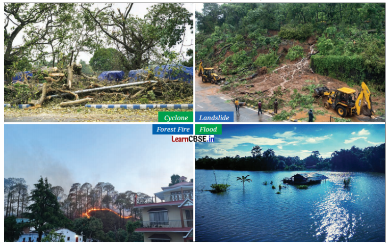
Which of the following best describes a cyclone?
  • A
    High-pressure system over the sea
  • B
    Rotating storm with high-speed winds
  • A type of wind system that moves toward the poles
  • D
    A local wind phenomenon Answer:

Answer: C.

View full solution
Q 3MCQ (1 Mark)1 Mark
Why do higher altitude areas have lower temperatures?
  • A
    More exposure to the Sun
  • Thinner air cannot retain heat
  • C
    Stronger winds at high altitudes
  • D
    Increased cloud cover

Answer: B.

View full solution
Q 5MCQ (1 Mark)1 Mark
What is the primary cause of monsoons in India?
  • A
    Rotation of the Earth
  • Differences in land and sea temperatures
  • C
    Movement of ocean currents
  • D
    Change in atmospheric composition

Answer: B.

View full solution
Assertion: Floods in India are caused mainly by heavy monsoon rains, overflowing rivers, and poor drainage systems.
Reason: Flood-prone areas like Assam, Bihar, and Kerala experience the worst flooding due to these factors
  • (a) Both (A) and (R) are true and (R) is the correct explanation of (A).
  • B
    Both (A) and (R) are true but (R) is not the correct explanation of (A).
  • C
    (A) is correct but (R) is wrong.
  • D
    (A) is wrong but (R) is correct.

Answer: A.

View full solution
Assertion: Coastal cities in India, like Mumbai and Chennai, have moderate temperatures throughout the year.
Reason: The cooling influence of the ocean on coastal areas keeps temperatures mild in both summer and winter.
  • (a) Both (A) and (R) are true and (R) is the correct explanation of (A).
  • B
    Both (A) and (R) are true but (R) is not the correct explanation of (A).
  • C
    (A) is correct but (R) is wrong.
  • D
    (A) is wrong but (R) is correct.

Answer: A.

View full solution
Assertion: Climate change in India has led to more frequent droughts.
Reason: The increasing unpredictability of monsoons due to climate change is a major factor contributing to droughts.
  • (a) Both (A) and (R) are true and (R) is the correct explanation of (A).
  • B
    Both (A) and (R) are true but (R) is not the correct explanation of (A).
  • C
    (A) is correct but (R) is wrong.
  • D
    (A) is wrong but (R) is correct.

Answer: A.

View full solution
Assertion: The Western Ghats receive heavy rainfall due to their location and topography.
Reason: The Western Ghats block moisture-laden winds, causing them to rise and cool, resulting in heavy rainfall.
  • (a) Both (A) and (R) are true and (R) is the correct explanation of (A).
  • B
    Both (A) and (R) are true but (R) is not the correct explanation of (A).
  • C
    (A) is correct but (R) is wrong.
  • D
    (A) is wrong but (R) is correct.

Answer: A.

View full solution
Assertion: Cyclones primarily form over warm ocean waters.
Reason: The low-pressure system created by rising warm air causes the surrounding cooler air to rush in, forming strong winds and heavy rainfall.
  • (a) Both (A) and (R) are true and (R) is the correct explanation of (A).
  • B
    Both (A) and (R) are true but (R) is not the correct explanation of (A).
  • C
    (A) is correct but (R) is wrong.
  • D
    (A) is wrong but (R) is correct.

Answer: A.

View full solution
Q 26VSQ (2 Marks)2 Marks
Make a colourful poster showing festivals in India linked to farming and weather (e.g., Baisakhi, Onam). Add pictures or drawings of these festivals.
View full solution
Q 27VSQ (2 Marks)2 Marks
Draw the monsoon cycle in summers and winters on a map of India.
→ Label where the winds blow in summer and winter.
→ Show the direction of winds during the monsoon.
View full solution
Look at a map of India given below. Identify the climate for these cities Leh, Chennai, Delhi, Panaji and Jaipur.
• Is the place near the sea, near the mountains, or in the desert?
• How do these factors affect the climate there?
Image
View full solution
Reach out to your grandparents or elders in your neighbourhood. Ask them about the traditional festivals and dances they remember from their childhood and youth, especially those related to agriculture and rain. What rituals did they participate in? Then organize a cultural fest with your friends. You can showcase some of the dances, songs, and activities your elders shared with you. Whether it is a dance, harvest ritual, or a simple story about prayer to rain gods, try to bring these traditions to life for your classmates.
View full solution
Discuss in groups of three or four and find out whether there are specific events connected to the seasons in your region. Collect information about them songs, feasts with specific types of food, practices in different seasons, etc. Document these and share your discoveries with your class.
View full solution
Identify a natural disaster (e.g., cyclone, flood, tsunami, landslide, or forest fire) and write a short essay that includes the causes and impacts. Suggest actions that individuals, communities and the government can take to reduce the impact.
View full solution
Observe the below figure and answer the questions that follow:
Image
(i) Identify the type of disaster and describe the effects they may have on people, plants, animals and economic life.
(ii)In groups of four or five, identify in each of the above disasters the part of natural causes and the part of human causes. Compare your conclusions.
(iii) Discuss in the same groups series of preventive measures that could help avoid the above disasters.
View full solution
Since the ability to predict the monsoon rainfall has been an important aspect of life in India, our ancestors observed Nature around them carefully. They developed local traditional knowledge through their experience. This traditional knowledge is an important heritage we must preserve. For example, fishermen on the Konkan coast predict the onset of the monsoon when fishes that normally stay under water are seen at the surface; in parts of southern India monsoon is said to arrive within 50 days after the Golden Shower tree (Cassia fistula) blossoms. Some communities also believe that when crows build their nests high on tree-tops, it indicates less rainfall, whereas if the nests are lower, rainfall is likely to be heavy. Make a list of such local knowledge about rain, fog, snow or hail in your area.
View full solution
Udhagamandalam (Ooty) and Coimbatore are almost at the same latitude. The range of summer temperatures in Ooty is 10-25°C while that in Coimbatore is 25-38°C. Why do you think there is such a difference in temperature between these two places?
View full solution
Do you know which trees in your area change colours before the onset of winter? Are there trees that shed their leaves around this time? Why do you think this happens? Find out and document the local names of these trees.
View full solution

Generate a Climates of India paper free

Pick question groups from the list above, set marks and difficulty, and export a branded PDF with step-by-step answer keys. First 3 chapters free — no signup.

Download App