Questions

[3 Mark Question Answer]

🎯

Test yourself on this topic

14 questions · timed · auto-graded

Question 13 Marks
Picture study
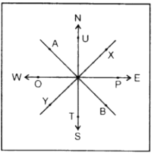
Study the diagram alongside and fill in the blanks with appropriate directions:
Example: A lies to the north-west of B.
1. T lies to the – of U.
2. P lies to the – of 0.
3. 0 lies to the – of P.
4. Y lies to the – of X.
5. U lies to the – of T.
Image
Answer
1. T lies to the south of U.
2. P lies to the E of O.
3. O lies to the W of P
4. Y lies to the SW of X.
5. U lies to the N of T.
Image
View full question & answer
Question 23 Marks
Look closely at the political map of India in your atlas and make a note of your observations and calculations in your notebook.
Using the scale, calculate the distance between Delhi and Kolkata, Chennai and Thiruvananthapuram, and Mumbai and Panaji in kilometers.
Answer
1 cm = 61 km
Delhi and Kolkata 24 cm = 24 × 61 = 1464 km
Chennai and Thiruvananthapuram 10.3 cm = 628 km appropriate
Mumbai and Panaji 6.50 cm = 6.5 × 61 = 397 km
View full question & answer
Question 33 Marks
What is the grid system ? Why is it important?
Answer
A network of horizontal and vertical lines or latitudes and longitudes are drawn on a map or globe is called the grid system.
The grid system is an important feature of maps. It helps in locating places on the surface of the earth. For example, if you wanted to locate a place, you would look for its latitude and longitude. The location of the place would be at the intersection of its latitude and longitude.
View full question & answer
Question 43 Marks
Why is the key or legend an important element of a map?
Answer
A legend or key is an essential feature of any map. It explains the colours, signs, and symbols used in the map. It uses different colours to show the height or depth of an area above or below sea level respectively. It is provided near the top or the bottom of the map, either on the left-hand or right-hand side.
View full question & answer
Question 53 Marks
Describe any two ways of representing a map scale.
Answer
Map scales can be represented as
(a) Verbal or statement scale—i.e. the scale is stated in words as 1 cm = 5 km or 1 cm to 5 km. It means 1 cm on the map is equal to 5 km on the ground.
(b) Representative fractions — In this system, the numerator expresses the distance on the map, and the denominator represents the actual distance on the ground. Both should have the same units i.e. 1 cm on the map represents 50,000 cm on the ground.
R.F = distance on map cm / distance or ground cm
View full question & answer
Question 63 Marks
What is the difference between the cardinal directions and the intermediate directions? Draw a diagram to the intermediate directions.
Answer
The four major directions i.e. North, South, East, and West are called cardinal directions. The directions in between these four cardinal directions are called intermediate directions.
Image
E.g North, East, North-Northeast, Southwest, etc.
View full question & answer
Question 73 Marks
Explain the functions of the north line and legend on a map.
Answer
The direction on a map is measured with the help of the north line.
All maps have a key or a legend that explains the colours, signs, and symbols used in them.
The equator (0° latitude) divides the earth into the hemispheres — the northern and the southern hemispheres. All lines of latitude are measured from the equator.
View full question & answer
Question 83 Marks
Name the line of latitude that divides the earth into the northern and southern hemispheres.
Answer
The line of latitude that divides the earth into the northern and southern hemispheres is the equator (0°).
A network of horizontal and vertical lines or latitudes and latitudes are drawn on a map or globe is called the grid system. Latitudes are the horizontal east-west lines. The longest latitude is the equator (0°).
View full question & answer
Question 93 Marks
Name the features that are shown in blue, green, and brown colours on a map.
Answer
  • Blue : water bodies such as oceans, seas, bays, gulfs, lakes, rivers, streams.
  • Green : lowlands or plains, both coastal and those built by rivers.
  • Brown : hills, mountains, plateaus.
View full question & answer
Question 103 Marks
What are conventional signs and symbols?
Answer
A variety of colourful signs and symbols are used on maps to show natural and man-made features on maps. These signs and symbols give plenty of information and are simple to draw and understand.
Some of these symbols are internationally recognized as they have been determined by convention, i.e., these symbols have been agreed upon and accepted internationally. Therefore, they are also called conventional signs and symbols.
View full question & answer
Question 113 Marks
What is a legend or key?
Answer
A legend or key is an essential feature of any map. It explains the colours, signs, and symbols used in the map. It uses different colours to show the height or depth of an area above or below sea level respectively. It is provided near the top or the bottom of the map, either on the left-hand or right-hand side.
View full question & answer
Question 123 Marks
What method would you use to measure the length of a river?
Answer
We use a twine method to measure the length of a river. In the twine method, a twine is placed along the feature to be measured from one end to the other, carefully following all the curves and bends. The length of the twine is then measured in centimeters or inches using a ruler or linear scale. Thereafter, this length is converted into kilometers or miles using the scale of the given map.
View full question & answer
Question 133 Marks
Which three ways are used to represent the scale of a map?
Answer
The proportion which exists between the map and actual surface of the Earth is called the scale. A scale can be expressed in three ways
  1. by a statement
  2. by representative fraction
  3. linear scale or graph
View full question & answer
Question 143 Marks
What are the cardinal directions?
Answer
N may or may not be shown the top of the map or plan indicates the North direction. If no such symbol is shown, then the top portion of the map is taken as the North and the bottom, right and left of the map as the South, the East, and the West respectively. These directions—North, South, East, and West — are called the cardinal directions.
Image
View full question & answer
[3 Mark Question Answer] - Geography STD 6 Questions - Vidyadip