To the foothills of the Aravalis _________.
- Alies the Budelkhand Plateau
- Blies the Malwa Plateau
- ✓lies the Mewad Plateau
- Dlies the Deccan Plateau
Answer: C.
View full solution →156 questions across 10 question groups — pick any mix to generate a Social Studies paper with step-by-step answer keys.
MCQ
28 Q→02Identify the wrong pair in the following and rewrite.
8 Q→03Answer the following in one sentence
38 Q→04Answer the following questions in detail
11 Q→05Write short notes on
15 Q→06Explain the following statements with its reason.
4 Q→07Write short notes
15 Q→08Identify the correct co-relation and complete the chain.
4 Q→09Do as directed.
29 Q→10Observe the following diagram and answer the following questions
4 Q→One sample from each question group in this chapter. Select any group above to see the full set with answer keys.
Answer: C.
View full solution →Answer: B.
View full solution →Answer: B.
View full solution →Answer: C.
View full solution →Answer: C.
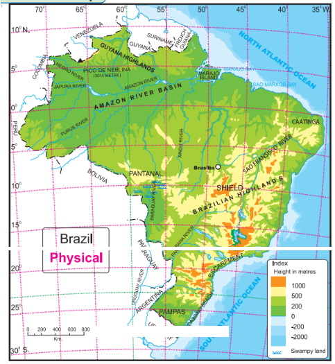
View full solution →| S.no | Column ‘A’ | Column ‘B’ |
| 1. | Longest river of India | (a) Sao Francisco |
| 2. | Second largest river of India | (b) Godavari |
| 3 | Longest river of Brazil | (c) Ganga (d) Brahmaputra (e) Amazon |
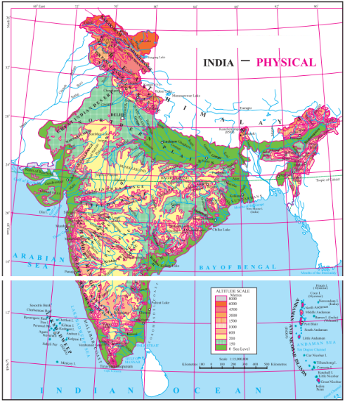
| Column ‘A’ | Column ‘B’ |
| (1) The southernmost point of India | (a) Gangotri |
| (2) The highlands in eastern Brazil | (b) Andes mountains |
| (3) The origin of Ganga | (c) Guyana Highlands |
| (4) The origin of Amazon | (d) Indira Point |
| (5) The southern most point of mainland India | (e) Kanyakumari |
| (f) The Great Escarpment |
| Column ‘A’ | Column ‘B’ |
| (1) Himalayas | (a) the western and eastern part of the Peninsula. |
| (2) North Indian Plains | (b) consists of many plateaus and hill ranges |
| (3) The Peninsula | (c) one of the young fold mountains in the world. |
| (4) The Coastal Plains | (d) lies between Himalayan mountains in the north and the Peninsula in the south. |
| (5) The Island group | (e) are located more than 300 km away from the mainland in the Atlantic ocean. |
| (f) small and large islands along the coast of the mainland. |
| Column ‘A’ | Column ‘B’ |
| (1) Western Himalayas | (a) Siwaliks |
| (2) Central Himalayas | (b) Assam Himalayas |
| (3) Eastern Himalayas | (c) Kashmir Himalayas |
| (d) Kumaun Himalayas |
Pick question groups from the list above, set marks and difficulty, and export a branded PDF with step-by-step answer keys. First 3 chapters free — no signup.