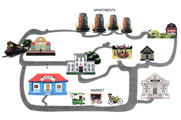
Question types

Locating Places on the Earth question types

149 questions across 11 question groups — pick any mix to generate a Social Studies paper with step-by-step answer keys.

149
Questions
11
Question groups
5
Question types
Sample Questions

Locating Places on the Earth questions

One sample from each question group in this chapter. Select any group above to see the full set with answer keys.
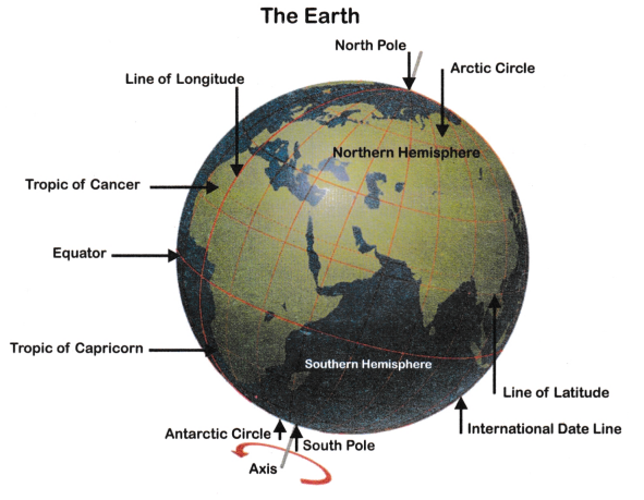
Delhi's and Bengaluru's latitudes are 29°N and 13°N; their longitudes are almost the same, 77°E. How much will be the difference in local time between the two cities?
View full solution
Now measure the diagonal of the rectangle. How many centimetres do you get? Using the scale, calculate the real length of the playground's diagonal, in metres.
View full solution
If the globe or atlas in your class has well-marked latitudes and longitudes, try to note down approximate values for the latitude and longitude of,
(1) Mumbai,
(2) Kolkata,
(3) Singapore,
(4) Paris.
View full solution
Draw a simple map of a school's playground. Let us assume it is a rectangle, 40 m in length and 30m in width. Draw it precisely with your ruler on a scale of 1cm = 10m
View full solution
Analyse the importance of latitude and longitude in navigation and global positioning. Describe how these coordinates are used to locate places on Earth and explain their role in time zone determination.
View full solution
How do physical and political maps differ in terms of the information they present and their applications? Provide detalled examples of each type of map and discuss their relevance in various fields.
View full solution
It is the third important component of a map. It is not possible to draw on a map the actual shape and size of different features such as buildings, roads, bridges, trees, railway lines or a well. So, they are shown by using certain letters, shades, colours, pictures and lines.
These symbols give a lot of information in a limited space. With the use of these symbols, maps can be drawn easily and are simple to read. Even if you don’t know the language of an area and therefore cannot ask someone for directions, you can collect information from maps with the help of these symbols.
Maps have a universal language that can be understood by all. There is an international agreement regarding the use of these symbols. These are called conventional symbols.

(i) Which component of the map is useful for representing the features like buildings, roads, bridges, trees or railway lines?
(ii) Mention any one benefit of using the symbols in the map.
(iii) Why are different features shown by symbols on a map?
View full solution
Image
(i) What is the value of the Prime Meridian?
(ii) Which important latitude passes nearly midway through India?
(ii) India lies in which hemisphere.
(iv) What is an equator?
(v) What is the latitudinal value of the Tropic of Cancer?
(vi) What is the name given to the top half of the globe?
View full solution
Consider the map of the small city again. Identify the correct and incorrect statements in the list below:
(i) The market is north of the hospital.
(ii) The museum is south-east of the bank.
(iii) The railway station is north-west of the hospital.
(iv) The lake is north-west of the apartment blocks.
View full solution
The best means of measuring time is by the movement of the Earth, the Moon and the planets. The Sun regularly rises and sets every day and naturally, it is the best time-keeper throughout the world. Local time can be reckoned by the shadow cast by the Sun, which is the shortest at noon and longest at sunrise and sunset. When the Prime Meridian of Greenwich has the Sun at the highest point in the sky, all the places along this meridian will have mid-day or noon.
As the Earth rotates from West to East, those places East of Greenwich will be ahead of Greenwich time and those to the West will be behind it. The rate of difference can be calculated as follows. The Earth rotates 360° in about 24 hours, which means 15° an hour or 1° in four minutes. Thus, when it is 12 noon at Greenwich, the time at 15° East of Greenwich will be 15 × 4 = 60 minutes, i.e., 1 hour ahead of Greenwich time, which means 1 pm but at 15° West of Greenwich, the time will be behind Greenwich time by 1 hour, i.e., it will be 11.00 am Similarly, at 180°, it will be mid-night when it is 12 noon at Greenwich.

(i) How is local time affected in places East of Greenwich ?
(a) Local time is behind Greenwich time.
(b) Local time is ahead of Greenwich time.
(c) Local time is the same as Greenwich time.
(d) Local time is not affected.

(ii) How is local time determined according to the passage ?
(a) By the movement of the Moon.
(b) By the shadow cast of the Sun.
(c) By the rotation of the planets.
(d) By the position of the Prime Meridian.

(iii) How does the Earth’s rotation affect time in different places ?
(a) It causes variations in local time.
(b) It determines the length of the day.
(c) It influences the movement of the Moon.
(d) It creates differences in sunrise and sunset times.

(iv) How is the time difference calculated between two locations, according to the passage ?
(a) By the length of the day.
(b) By the Earth’s revolution around the Sun.
(c) By multiplying the distance by 4 minutes.
(d) By calculating the Moon’s position.
View full solution
Our planet earth is not a sphere. It is sliehtlv flattened at the North and the South Poles and bulges in the middle. Can you imagine how it looks? You may look at a globe carefully in your classroom to get an idea. Globe is a true model (miniature form) of the earth. On the globe, countries, continents and oceans are shown in their correct size. It is difficult to describe the location of a point on a sphere like the earth, a needle is fixed through the globe in a tilted manner, which is called its axis. Two points on the globe through which the needle passes are two poles – North Pole and South Pole. The globe can be moved around this needle from west to east just as the earth moves. But, remember there is a major difference. The real earth has no such needle. It moves around its axis, which is an imaginary line. Another imaginary line running on the globe divides it into two equal parts. This line is known as the Equator. The northern half of the earth is known as the Northern Hemisphere and the southern half is known as the Southern Hemisphere. They are both equal halves. Therefore, the equator is an imaginary circular line and is a very important reference point to locate places on the earth. All parallel circles from the Equator up to the poles are called parallels of latitudes. Latitudes are measured in degrees.
Q.1.Which among the following are shown on the globe in their true size?
(a) Countries $\quad$ (b) Continents $\quad$ (c) Oceans $\quad$ (d) All of these
Q.2.A needle fixed through the globe in a tilted manner is called as:
(a) orbit $\quad$ (b) axis $\quad$ (c) latitude $\quad$ (d) longitude
Q.3.An imaginary line that divides globe into two equal parts is known as:
(a) Tropic of Cancer $\quad$ (b) Arctic Circle $\quad$ (c) Tropic of Capricorn $\quad$ (d) Equator
Q.4.Northern half of the earth is known as:
(a) Northern hemisphere 
(b) Southern hemisphere
(c) Equator
(d) None of the above
View full solution
A globe can be useful when we want to study the earth as a whole. But, when we want to study only a part of the earth, as about our country, states, districts, towns and villages, it is of little help. In such a situation we use maps. A map is a representation or a drawing of the earth’s surface or a part of it drawn on a flat surface according to a scale. But it is impossible to flatten a round shape completely. We find that maps are useful to us for various purposes. One map shows a small area and a few facts. Another map may contain as many facts as a big book. When many maps are put together we get an Atlas. Atlas is of various sizes, measurements drawn on different scales. Maps provide more information than a globe. They are of different types. Some of them are described below. Maps showing natural features of the earth such as mountains, plateaus, plains, rivers, oceans, etc., are called physical or relief maps. Maps showing cities, towns and villages, and different countries and states of the world with their boundaries are called political maps. Some maps focus on specific information, such as road maps, rainfall maps, maps showing distribution of forests, industries, etc., are known as thematic maps. Suitable titles are given on the basis of information provided in these maps.
Q.1.__________ is the representation of the earth’s surface drawn on a flat surface according to a scale,
(a) Map $\quad$ (b) Globe $\quad$ (c) Plan $\quad$ (d) Scale
Q.2.Atlas is known as:
(a) Globe
(b) Collection of different maps
(c) Both (a) and (b)
(d) None of the above
Q.3.Which maps show the natural features of the earth such as mountains, plateaus, plains, rivers, oceans, etc.?
(a) Physical maps
(b) Relief maps
(c) Both (a) and (b)
(d) None of these
Q.4.What does political map show?
(a) It shows natural features of the earth
(b) It shows cities, towns and villages with boundaries
(c) It shows rainfall, distribution of forests, etc.
(d) None of the above
View full solution

1. Tropic of Cancer

(i) 66$1 / 2^{\circ}$ S of the Equator

2. Tropic of Capricorn

(ii) Torrid zone

3. Arctic Circle

(iii) 23 $1 / 2^{\circ}$ S in the Southern Hemisphere

4. Antarctic Circle

(iv) 23$1 / 2^{\circ}$ N in the Northern Hemisphere

5. Equator

(v) 66$1 / 2^{\circ}$ N of the Equator

View full solution

1. Latitude

(a) $0^{\circ}$ longitude

2. Prime Meridian

(b) Halfway between poles

3. Equator

(c) Measures distance from the Equator

4. Meridians of longitude

(d) Grid lines on a globe

5. Scale

(e) $0^{\circ}$ longitude

View full solution
List I (Symbols)List II (Representation)
A. Equator1. The line that divides the Earth into two halves.
B. Cardinal points2. Point to four directions (North, East, South and West)
C. Uijayini3. Indian Prime Meridian
D. Prime Meridian4. Accepted by all nations as the International Standard Time
 
View full solution
Assertion: The Tropic of Cancer and Tropic of Capricorn are near the poles.
Reason: India lies entirely in the Northern hemisphere.
  • A
    Both Assertion (A) and Reason (R) are true, and Reason (R) is the correct explanation of Assertion (A).
  • B
    Both Assertion (A) and Reason (R) are true, but Reason (R) is not the correct explanation of Assertion (A).
  • C
    Assertion (A) is true but, Reason (R) is false.
  • D
    Assertion (A) is false but, Reason (R) is true.
View full solution
Assertion: The standard meridian of India passes through is the $71^{\circ}$ longitude.
Reason: The time of India is 5 h. 30 min. ahead of the Greenwich Meridian Time.
  • A
    Both Assertion (A) and Reason (R) are true, and Reason (R) is the correct explanation of Assertion (A).
  • B
    Both Assertion (A) and Reason (R) are true, but Reason (R) is not the correct explanation of Assertion (A).
  • C
    Assertion (A) is true but, Reason (R) is false.
  • D
    Assertion (A) is false but, Reason (R) is true.
View full solution
Assertion: The political maps and the physical maps have no difference.
Reason: The political maps depict the towns and cities on the maps.
  • A
    Both Assertion (A) and Reason (R) are true, and Reason (R) is the correct explanation of Assertion (A).
  • B
    Both Assertion (A) and Reason (R) are true, but Reason (R) is not the correct explanation of Assertion (A).
  • C
    Assertion (A) is true but, Reason (R) is false.
  • D
    Assertion (A) is false but, Reason (R) is true.
View full solution
Assertion (A): The International Date Wine helps in changing the date.
Reason (R): The International Date Line is located at $0^{\circ}$ longitude.
  • A
    Both (A) and (R) are true and (R) is the correct explanation of (A).
  • B
    Both (A) and (R) are true but (R) is not the correct explanation of (A).
  • (A) is correct but (R) is wrong.
  • D
    (A) is wrong but (R) is correct.

Answer: C.

View full solution
Assertion (A): A physical map shows countries and their boundaries.
Reason (R): A physical map includes natural features like mountains and rivers.
  • A
    Both (A) and (R) are true and (R) is the correct explanation of (A).
  • B
    Both (A) and (R) are true but (R) is not the correct explanation of (A).
  • C
    (A) is correct but (R) is wrong.
  • (A) is wrong but (R) is correct.

Answer: D.

View full solution

Generate a Locating Places on the Earth paper free

Pick question groups from the list above, set marks and difficulty, and export a branded PDF with step-by-step answer keys. First 3 chapters free — no signup.

Download App