Question
1.Which meridian is used to determine world standard Time (GMT)?
2.Which meridian determines Indian Standard Time (1ST)?
3.What is the time difference between the GMT and the IST?
1.Which meridian is used to determine world standard Time (GMT)?
2.Which meridian determines Indian Standard Time (1ST)?
3.What is the time difference between the GMT and the IST?
Generate a complete, print-ready paper with questions like this in minutes — across 16+ boards, with answer keys.
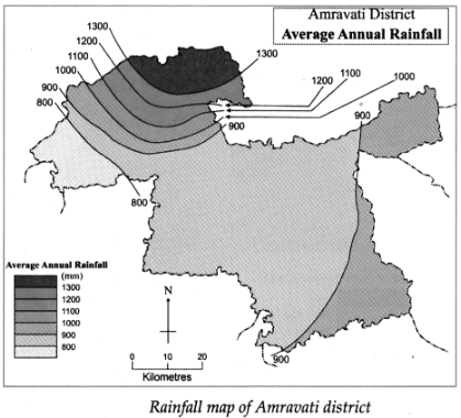
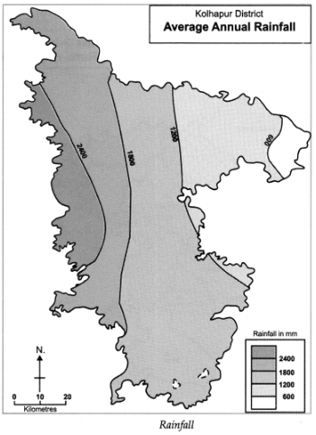
1.In which part of the district is the rainfall more?
2.In which direction is the rainfall decreasing?
3.What is the lowest value of the rainfall in the district?
4.What is the highest value of the rainfall in the district?
5.What is the amount of rainfall in the central part of the district?
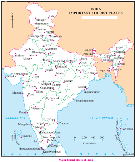
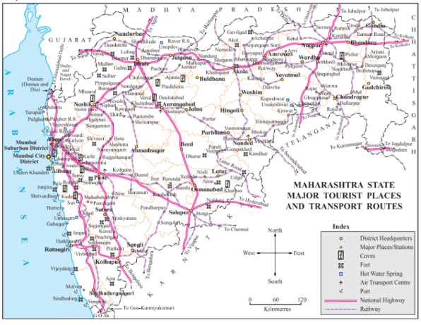
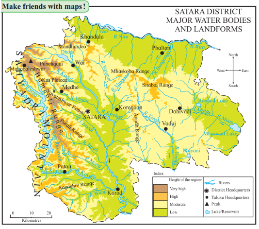
1.Out of these, which tourist places1 do you know? Make a list.
2.For what are the selected places famous?
3.Make a list of religious and historical sites from the map.
4.Make a list of hill stations, places having sanctuaries and places along the coasts.
5.Correlate the physiography and tourist places in India.
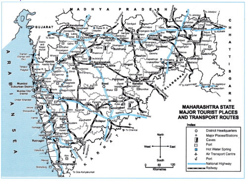
1.Name the ports of Konkan coast and is there any connectivity of ports with tourism?
2.Name some of the caves in Maharashtra.
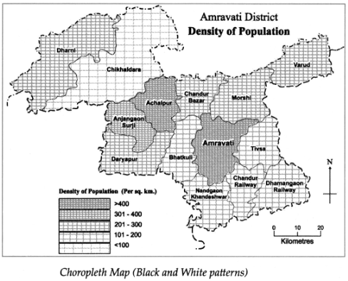
1.Name the talukas having population density between 301 and 400 persons per sq km.
2.What is the density of the Amravati taluka?
3.Name the talukas having population density less than 300 persons per sq km.
4.Which taluka has a population density of less than 100 persons per sq km?
5.Which Talukas have a population density of more than 400 persons per sq km?
1.Make a list of places having hot springs. What are the reasons for these being located here?
2.At what places do you find the correlation between transportation routes and the development of tourism?
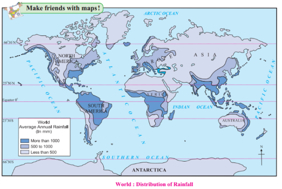
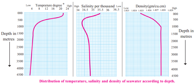
1.Which region experiences more rainfall?
2.What is the reason for low rainfall in the Central Peninsular India?
3.Why does the eastern part of Central African continent gets less rainfall than the western part despite its location close to the equator?
4.Why does the amount of high rainfall in the western part of the European continent reduce in the eastern part?
5.Why is rainfall more only in the eastern coast of Australia?
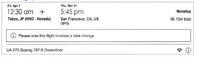
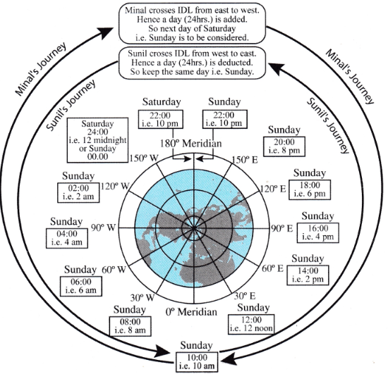
1.From which country will the plane take off and where will it go?
2.What is the duration of the flight?
3.What is the day, date and time given at the starting point and destination of the flight?
4.What special note is given on the air ticket?
5.What could be the reason behind giving such a note?
6.During this flight, will the plane cross the IDL? If yes, then from which direction to which direction?
7.What did you understand by reading the ticket?
1.In which region do you find a dense network of transport routes in the map?
2.How is the physiography of the region with dense network?
3.Which region has a sparse network of transport routes?
4.How is the physiography of this region?
5.Look for the region lacking transport routes.
6.What kind of obstruction can you find there?
1.In which direction is the rainfall more in the district?
2.In which direction is the rainfall decreasing?
3.Which class shows low rainfall category in the district?
4.Which class shows high rainfall category in the district?
5.Which class shows high rainfall category in the district?