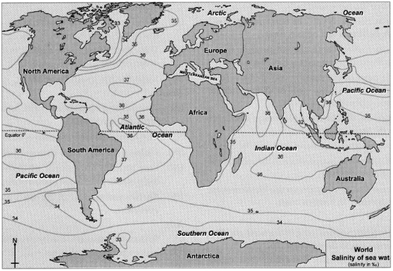
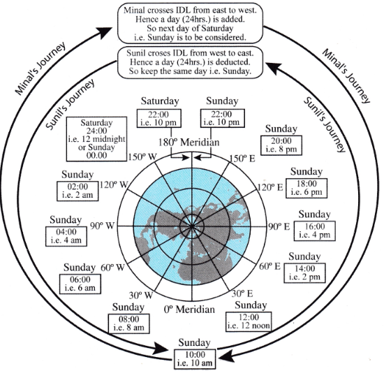
Question

Image
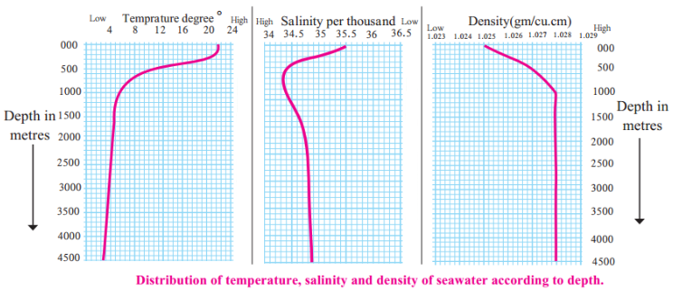
1.With increasing depth, what decreases: temperature, salinity or density?
2.After what depth does the change in these factor become almost zero?
3.Till what depth is the change in these factors higher?
4.Explain the correlation between all the three factors.

Answer

1.Temperature and salinity decreases with increasing depth.
2.After the depth of 1000 m there is no change in all these factors.
3.The higher change can be seen up to a depth of about 500m.
4.If the temperature is less, density is more. If the salinity is less, then density is also less. However temperature affects the density more as compared to the salinity. If the temperature is less, then the density is more despite less salinity.

Need a full question paper?

Generate a complete, print-ready paper with questions like this in minutes — across 16+ boards, with answer keys.

Start Generating Free

Similar questions


Image

1.What is the salinity around the tropics?
2.Which region has the least salinity?
3.Which ocean has salinity more than 37%o?
4.What are the reasons of differences in salinity on a global level?


Image

1.In which direction is the rainfall more in the district?
2.In which direction is the rainfall decreasing?
3.Which class shows low rainfall category in the district?
4.Which class shows high rainfall category in the district?
5.Which class shows high rainfall category in the district?


1.What is the maximum temperature of seawater in equatorial areas? How much is this temperature at a depth of 500 m?
2.What is the temperature of seawater at the sea level in the mid-latitudes?
3.How much has this temperature changed at 1500 m depth?
4.What does the thermal graph for the high latitude say? What is its temperature at 500, 1000 and 1500 m depths?
5.After what depth does the seawater temperature remain stable everywhere?


Image
1.What type of rainfall occurs in Maharashtra?
2.Where will the rain shadow area lie in Maharashtra?
3.Think about the figure and estimate the rainfall of your district.

Image

1.What is the population of the Amravati town?
2.Name the place having population of 1 lakh on the map.
3.Which part of the map shows sparse distribution of population?


Image

1.Which meridian is used to determine world standard Time (GMT)?
2.Which meridian determines Indian Standard Time (1ST)?
3.What is the time difference between the GMT and the IST?


Image

1.Name the ports of Konkan coast and is there any connectivity of ports with tourism?
2.Name some of the caves in Maharashtra.

Image

1.In which part of the district is the rainfall more?
2.In which direction is the rainfall decreasing?
3.What is the lowest value of the rainfall in the district?
4.What is the highest value of the rainfall in the district?
5.What is the amount of rainfall in the central part of the district?


Image

1.In which direction is the density of population decreasing?
2.Name the talukas with a population density less than 200.
3.Name the talukas having population density between 200 and 400.
4.Name the talukas with a population density more than 400.
5.In which direction are the talukas having a higher density of population located in the district?
6.Which method has been used in the making of this map?


Image

1.Out of these, which tourist places1 do you know? Make a list.
2.For what are the selected places famous?
3.Make a list of religious and historical sites from the map.
4.Make a list of hill stations, places having sanctuaries and places along the coasts.
5.Correlate the physiography and tourist places in India.