Human Settlements and Land Use — Geography STD 12 Commerce / Arts — Question
Maharashtra BoardEnglish MediumSTD 12 Commerce / ArtsGeographyHuman Settlements and Land Use4 Marks
Question
✓
Answer
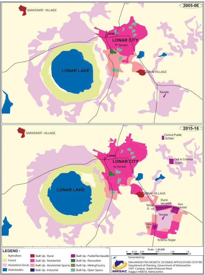
Two maps of Lonar city are given. One map is of the year 2005-06 and another is of 2015-16.
These two maps show the changes in land use that have taken place in the span of 10 years.
The following changes have been registered.
There is no change in the size of Lonar lake.
The area occupied by Lonar city has increased substantially.
Forest area around the lake has increased.
An area under waste land/ scrubs have increased.
Around the temple in the southeast, on the waste scrub land a new rural hospital, government hostel, government ITI, Tahsil office etc., has been developed. This newly developed area has been named as Krishna Nagar, which is not in 2005-06 map.
To the north-east of the Lonar city two more building have been constructed. One is central public school and another is civil and criminal court.
To the south of the temple in the heart of Lonar city built up residential area is spreading over built up residential sparse.
Overall built up residential sparse is increasing in all directions around Lonar lake and south-eat of the Lonar city and thus there is encroachment over agricultural land.
Need a full question paper?
Generate a complete, print-ready paper with questions like this in minutes — across 16+ boards, with answer keys.