Question
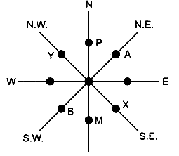
How the compass direction of an object, feature or place given from the given point?

Need a full question paper?

Generate a complete, print-ready paper with questions like this in minutes — across 16+ boards, with answer keys.

Start Generating Free

Similar questions

Explains the role of an individual in maintaining environmental standards.
Show the following on the outline map provided:

(a) Shade and label the Satpura Range.
(b) Label the River Krishna.
(c) Label the River Ravi.
(d) Shade and label the Khasi Hills.
(e) Mark with arrows the direction of the North-East Monsoon winds over the Bay of Bengal.
(f) Mark and label the Malabar coast.
(g) Shade and label an area of Laterite soil in India.
(h) Shade and label an area of Limestone in India.

Give reasons to justify that the Himalayas act as a ‘climatic divide’.
What are the problems of the Handloom industry?
Mention the important features of a river valley.
Study the extract of the Survey of India Map sheet No. 45D/10 and answer the following questions:
(a) Give the six figure grid reference of:
(i) the brick kiln
(ii) the temple near Asav.
(b) What is the difference in the pattern of drainage in grid square 0916 and in 0712?
(c) Give the four figure grid reference of each of the following:
(i) Stony waste
(ii) Open scrub.
(d) Calculate the distance in kilometres along the metalled road between the causeways in grid square 0512 and 0808.
(e) (i) What do the tiny curved black lines in grid square 0315 indicate?
(ii) What is the main cause for this feature?
(f) (i) What is the geographical name that you would give to the general pattern of settlements in the region shown on the map?
(ii) Give a reason for your answer.
(g) What is the general direction of flow of the Sipu Nadi, given in the map extract? Give a reason to support your answer.
(h) Name two probable occupations of the people in the settlement of Revdar in grid square 0313 and 0413.
(i) What kind of roads connect (i) Marol with Mitan and (ii) Revdar with Karaunti respectively?
(j) Give two reasons to show that the area depicted in the map experiences seasonal rainfall.
Why should we save rain water?
(i) On a topographical map two stations A and B are situated at height of 500 metres and 100 metres respectively. If the horizontal distance between them is 2 km, calculate the gradient.
(ii) On a topographical map, two places A and B are given. Calculate the gradient between them.
What is incineration? Give advantage and disadvantage of incineration.
Name the five most important peaks of the Himalayan Range.