Questions

[5 Mark Question Answer]

🎯

Test yourself on this topic

28 questions · timed · auto-graded

Question 15 Marks
Answer the following questions on the Survey Sheet Number 45 D/10. Eastings 00 to 10; Northings 17 to 28. (Map G)
(a) Give four-figure grid references of the following:
(i) Dhad Talao (ii) Sheet rock in the North-east
(iii) Rock outcrop in the North (iv) Stony waste in the South-east
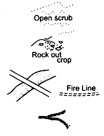
(v) Open scrub south of Dhad Talao
(b) Give the six-figure grid references of the following:
(i) Police Chowki in village Dantral
(ii) Temple in Bhamra village
(iii) Well with water in settlement Devka
(iv) Spot height 310 near village Jolpur
(v) Tank near Indaria settlement
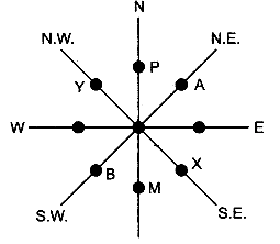
(c) Give-the direction of the following:
(i) Village Dantral (0324) from Dhann (0723)
(ii) Village Bhamra (0521) from Dhann (0723)
(iii) Village Jolpur (0718) from Malawa (0519)
(iv) Village Warka (0716) from Bikanwas (0316)
(v) Village Rampura (0617) from Dhann (0723)
(d) Give the meanings of the following:
(i) 15r in blue in grid square 0224.
(ii) 300 in brown in grid square 0426.
(iii) Black line in the northernmost part of the map.
(iv) Red line in grid square 0819.
(v) Black dots in grid square 0617.
(e) Give the settlement patterns of the following:
(i) Village Dhann (ii) In grid square 0220
(f) Measure the distances of the following:
(i) Direct distance in km. from Indaria (0826) to Jolpur (0718)
(ii) Indirect distance in km. along the cart track from Dantral (0324) to Dhann (0723)
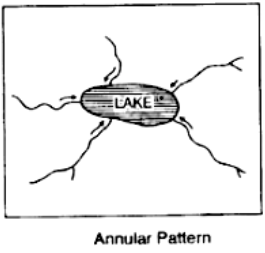
(g) Give the drainage patterns of the following:
(i) 0827 (ii) In grid square 0226
(h) Name three man-made features found in grid square 0419 and draw their symbols.
(i) Give two evidences that the region gets seasonal rainfall.
(j) Explain the nature of the river.
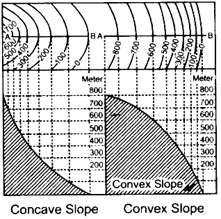
(k) Explain the relief of the area.
(l) What is the general slope of the land? Give reason for your answer.
(m) What is the main occupation of the people? Give reason for your answer.
(n) What is the mode of irrigation? Give reasons for your answer.
(o) What is the mode of transport? Give reasons for your answer.
Answer
(a)
(i) 0722
(ii) 0826
(iii) 0526
(iv) 0918
(v) 0721
(b)
(i) 032238
(ii) 050210
(iii) 019187
(iv) 075188
(v) 085259
(c)
(i) North-west
(ii) South-west
(iii) East
(iv) East
(v) South.
(d)
(i) 15r means relative depth of the perennially lined well is 15 m.
(ii) Contour line of 300 m.
(iii) 24° 45′ is the northern most latitude shown on the map extract.
(iv) Cart track.
(v) It is a natural seasonal tank with embankment.
(e)
(i) The general pattern of Dhann village is clustered settlement type.
(ii) The general pattern is scattered or dispersed settlement type.
(f)
(i) Direct distance between Indaria and Jolpur is 14 cm.
1 cm., on the map equals 500 m. on the ground
14 cm., equals 500 × 14 = 7000 m., or 7 kms.
(ii) Distance along cart track between Dantral and Dhann is 8 cm.
1 cm. on the map equals 500 m.
8 cm. equals 500 × 8 = 4000 m., or 4 kms.
(g)
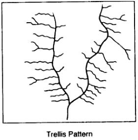
(i) The drainage pattern is trellis.
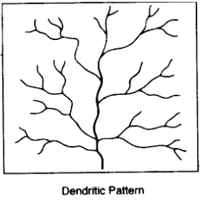
(ii) The drainage pattern is dendritic type resembles a tree.
(h) Temple, cart track, perennial lined well.
(i) The presence of broken ground and seasonal rivers.
(j) The main river Sukli Nadi flows in the southern direction is a seasonal river, the water courses are numerous and well defined as they are able to cut channels into the soft soil. They are periodic and rely on the monsoon rain for the water supply.
(k) The area is mainly a plain. The land is higher in the N.E., and slopes gently towards the S. W. There are some rock outcrops rising to a height of about 300 m. A larger part of the plain is sandy and presence of sand dimes indicates desert conditions.
(l) The land slopes from the north-east to the south. The highest spot height of 311 is seen in the N.E., section of the map and the S.W., section of the map shows a spot height of 263. The flow of the rivers from the N.E. to the S.W. is also an indication of the slope of the land.
(m) The main occupation of the people is agriculture. This is indicated in the map by the yellow wash that covers almost the entire map extract. The presence of a large number of perennial lined wells also supports this inference.
(n) Well irrigation is the most widespread mode of irrigation. This is because of the presence of a large number of perennial wells which have a supply of water throughout the year.
(o) The mode of transport is cart track. This is mainly because this is a rural area and most of these cart tracks connect villages in this region.
View full question & answer
Question 25 Marks
Study the extract of the Survey of India Map sheet No. 45D/10 and answer the following questions:
(a) 
Give the six figure grid reference of:
(i) Triangulated height 307.
(ii) The spot height 196.
(b) 
Give the four figure grid reference of each of the following:
(i) The confluence of the Sipu River and the Mahadeviyo Nala.
(ii) Sheet rock.
(c) Measure the shortest distance in kilometres between the temple in, grid square 8192, and the perennial lined well at Bhakodar 8188.
(d) 
What do the following represent?
(i) Black curved lines in 7788.
(ii) The blue line in the bed of the Sipu River.
(e) 
(i) What is the general pattern of settlements in the region shown on the map?
(ii) Give a reason for your answer.
(f) Which is the chief form of irrigation shown in the map extract? Why is it necessary?
(g) 
(i) What is the main form of transport in this region?
(ii) Give the map evidence for your answer.
(h) 
(i) What is the compass direction of Dantiwada, 8582, fromBhadli Kotha, 7886?
(ii) What is the general direction of flow of the Arado. N?
(i) 
(i) Name the type of drainage pattern found in grid square 8584.
(ii) What do you mean by 25r in grid square 8286?
(j) 
(i) What is meant by ‘R.F.’?
(ii) What is the R.F. shown on this map extract?
Answer
(a) (i) 859843 (ii) 860788.
(b) (i) 8189 (ii) 8188.
(c) 8 cm = 4 km.
(d)
(i) broken ground
(ii) perennial stream.
(e)
(i) Nucleated
(ii) There are a number of cart tracks connecting the settlements. People can take to farming.
(f) Perennial wells because the rivers are seasonal.
|(g)
(i) Carts.
(ii) single red lines shown on the map.
(h) (i) south-east (ii) north to south.
(i)
(i) dendritic
(ii) the relative depth of the perennial well is 25 metres.
(j)
(i) Representative fraction: It is the ratio of the horizontal distance between two points on the map to the distance of the corresponding points on the ground.
(ii) 1 : 50000.
View full question & answer
Question 35 Marks
Study the extract of the Survey of India Map sheet No. 45D/10 and answer the following questions:
(a) Give the six figure grid reference of:
(i) Triangulated height 217
(ii) A lined well near Chekhla.
(b) 
(i) Name the left bank tributary of the main river.
(ii) State the direction in which this left bank tributary is flowing.
(c) 
(i) Mention a special feature associated with the streams in grid square 9879.
(ii) Name the types of drainage pattern found in grid square 9382.(d) Give the four grid reference of each of the following:
(i) Open scrub
(ii) Bantawada.
(e) Name two relief features that can be seen in grid square 9782 and 9574.
(f) Why do you find limited cultivation in the map extract?
(g) What is the compass direction of Antroli (9576) and Chekhla (9281) from Sangla?
(h) What type of rainfall is experienced in the region shown in the map extract? Justify your answer giving one reason.
(i) Calculate the distance in kilometres along the cart track between Chitrasani (999747) and Pirojpura (978753).
(j) 
(i) What is the geographical name that you would give to the general pattern of settlements in the region shown on the map?
(ii) Name one region shown on the map which is unsuitable for the cultivation of crops.
Answer
(a) 
Six fig. grid reference are:
(i) D 217 – 940792
(ii) lined well – 925814.
(b)
(i) Left bank tributary is Balaram nadi.
(ii) It is flowing from SE to NW.
(c) 
(i) Feature associated with stream is broken ground.
(ii) Dendritic pattern.
(d) 
Four fig. grid reference
(i) Open scrub – 9573
(ii) Bantawada – 9978
(e)
Two relief features are:
9782 – Escarpment
9574-Ridge/watershed.
(f) Give two reasons for your answer.
There is limited cultivation in the map because
(i) Region is Sandy with Sandunes.
(ii) Presence of broken ground which is a waste land.
(g) 
Sangla to Antroli – North east.
Sangla to Chekhla – North.
(h)
This region experiences low and seasonal rainfall.
Reason-Rivers and Streams are seasonal.
(i) 
Distance in cm = 5.2
Distance in km = 5.2/2 (scale 2 cm. to 1 km.)
Distance in km = 2.6 km.
(j) 
(i) General pattern of settlement is Nucleated.
(ii) One region unsuitable for the cultivation of crops is broken ground/white coloured region which is a barren land.
View full question & answer
Question 45 Marks
Study the extract of the Survey of India Map sheet No. 45D/10 and answer the following questions:
(a) Give the six figure grid reference of:
(i) The temple in village Dhavli
(ii) ∆ 480
(b) What do the following indicate?
(i) 6r in grid square 1903
(ii) The word Brackish in grid square 1403.
(c) 
(i) In grid square 1909, several contours merge at one point. What does this represent?
(ii) State the significance of the red dotted lines in the map extract.
(d) Name the type of rainfall experienced in the region shown in the map extract. Give a reason to support your answer.
(e) How does the drainage pattern in grid square 1606 differ from the drainage pattern in grid square 1708?
(f) 
(i) What is the pattern of settlement in grid square 1904?
(ii) Name the settlement that has a post office.
(g) Name two landforms represented by the pattern of contours in grid square 1608.
(h) Calculate the ground distance in kilometres along the metalled road between the causeway in 1502 and the distance stone marked ’14’ in grid square 1203.
(i) State two reasons for the absence of human habitation in the north eastern region of the map extract.
(j) 
(i) Mention the difference in height between the highest spot height in the map extract and the contour height in grid square 1006.
(ii) What is the compass direction of Patlawa ka Goliya (590.) from Kacholi Dunga (443.)?
Answer
(a) (i) 111073 (ii) 138045.
(b) 
(i) The relative depth of the embankment is 6 m.
(ii) It is salty water.
(c) (i) Cliff (ii) Footpath.
(d) The rainfall is seasonal because most of the streams are dry not having water.
(e)
1606-radial
1708-Trellis.
(f) (i) Dispersed (ii) Dattani
(g) Pass and Spur.
(h) 3.5 km
(i) The region is mountaineous and does not have transport facilities.
(j) (i) 1023 – 260 = 763 m (ii) NW.
View full question & answer
Question 55 Marks
Study the extract of the Survey of India Map sheet No. 45D/10 and answer the following questions:
(a) What is the compass direction of Sunset Point from the settlement of Anadra?
(b) What is the pattern of drainage in grid square 2315?
(c) Mention any two features seen in the map extract which indicate that the region has seasonal rainfall.
(d) Calculate the distance, in kilometers along the metalled road from the causeway in grid square 1715 to the distance stone marked 20 in grid square 1818.
(e) What advantage does a Representative Fraction have over a verbal scale?
(f) Give the six figure grid reference of:
(i) Anjini Devi ka Mandir
(ii) D 1327.
(g) Name the three different kinds of roads in grid square 2411 and the one in grid square 2515.
(h) Mention two occupations of the people living in the northern part of the region in the map extract. Give reasons to support your answer.
(i) What is the difference between the slope in grid square 2115 and the one in 1811. Give a reason for your answer.
(j) What is the purpose of:
(i) the fireline in grid square 2316.
(ii) the pipeline in grid square 2209?
(k) What do the following represent?
(i) The red square in grid square 2514.
(ii) 4r in grid square 1612,
(l) Abu is a popular holiday resort. Mention any three features seen in the map extract which attract holiday makers to Abu.
Answer
(a) The compass direction of Sunset point from the settlement of Anadra is South-East.
(b) The drainage pattern in grid square 2315 is Radial.
(c) There is a dry ‘Nadi’ flowing from Lakhawa Ka Khera and also some dry tanks in that area which show that the region has seasonal rainfall, as when the rain falls these features ‘Nadi’ and Tanks are full of water.
(d) 9.6 cm = 2.8 km.
(e) Verbal Scale is not a suitable method of representing the scale of a map as in this method we make statements such as 1 cm = 1 km or 1 inch = 5 miles, but this type of statement can not be used in different parts of the world as they require to know the units of measurement. But in the Representative Fraction this problem is not there as the unit of measurement in the numerator and denominator is same.
for example : `(1 ("Distance on map"))/(100000 ("Distance on ground"))` or 1 : 100000
It means 1 unit on the map represents 1,00,000 units on the ground, if the unit of measurement is cm then it will be 1 cm on the map = 1,000 cm on the ground. The unit of measurement can be changed or converted to any unit. Thus it has its international value and called ‘International Scale’.
(f) 
(i) Anjini Devi ka Mandir is at 229160 six figured grid.
(ii) Six figured grid of D 1327 is = 217105.
(g) The three different kinds of roads in grid square 2411 are:
(i) Metalled Road (ii) Unmetalled Road (iii) Pack track
One kind of road in grid square 2515 is ‘Foot path’.
(h) The people living in the northern region of the map extract adopt two main occupation:
(i) Cultivation: On the north western region of the map extract people adopt cultivation as their occupation because the ‘yellow wash’ in this region shows that the land.is cultivable, secondly it has lot of perennial wells which supports the cultivation in this region.
(ii) Forestry: On the north eastern region there are evidences of the forests, as it is coloured in green colour and at two places its written ‘Fairly dense mixed jungle’ and ‘Open mixed jungle’ so the forestry is the main occupation of the people in this region.
(i) In grid square 2115 the slope is gradual and gentle as the contour lines drawn in this region are far a part from each other where as in 1811 the contour lines are drawn very close to each other which means it has steep slopes.
(j) 
(i) Fire line is a clearing made in the forest to prevent the spread of forest fire as shown in grid square 2316.
(ii) The pipe line in grid square 2209, takes the water from the perennial tank Kodra reservoir shown is southern part at 220090 grid to the main town ‘Abu’.
(k) 
(i) The red square in grid square 2514 show the ‘temporary hut’.
(ii) 4r is in grid square 1612 shows the relative height of the embankment on dry or seasonal tank is 4 metres.
(l) 
(i) Mt Abu is situated on a high altitude which provides pleasant climate, some of the peaks are 1409 and 1327 metres.
(ii) There are lot of temples to see as Anjini Devi ka Mandir, Adhor Devi ka Mandir, Dilwara Temple, etc.
(iii) It also provide scenic beauty such as the whole area is covered with forests, steep slopes attract people for mountaineering, sunset point and cave dwelling etc.
View full question & answer
Question 65 Marks
View full question & answer
Question 75 Marks
Study the extract of the Survey of India Map sheet No. 45D/10 and answer the following questions:
(a) Give the six figure grid reference of:
(i) the brick kiln
(ii) the temple near Asav.
(b) What is the difference in the pattern of drainage in grid square 0916 and in 0712?
(c) Give the four figure grid reference of each of the following:
(i) Stony waste
(ii) Open scrub.
(d) Calculate the distance in kilometres along the metalled road between the causeways in grid square 0512 and 0808.
(e) (i) What do the tiny curved black lines in grid square 0315 indicate?
(ii) What is the main cause for this feature?
(f) (i) What is the geographical name that you would give to the general pattern of settlements in the region shown on the map?
(ii) Give a reason for your answer.
(g) What is the general direction of flow of the Sipu Nadi, given in the map extract? Give a reason to support your answer.
(h) Name two probable occupations of the people in the settlement of Revdar in grid square 0313 and 0413.
(i) What kind of roads connect (i) Marol with Mitan and (ii) Revdar with Karaunti respectively?
(j) Give two reasons to show that the area depicted in the map experiences seasonal rainfall.
Answer
(a) 
(i) 089132
(ii) 059128
(b) 0916 trellis 0712 radial
(c) 
(i) 1014
(ii) 0816, 0916
(d) 5.5 kms
(e) 
(i) broken ground
(ii) caused due to erosion during heavy rain at the time of flooding.(f) 
(i) nucleated
(ii) people build their houses in areas where there are wells and they can do some farming. This is shown by yellow colour on the map.
(g) north east to south west. An arrow in the bed of the river indicates this.
(h) Farming and cattle grazing.
(i) 
(i) Marol to Mitan cart track.
(ii) Revdar to Karaunti metalled road.
(j) broken ground and stiples in the river.
View full question & answer
Question 85 Marks
Study the extract of the Survey of India Map sheet No. 45D/10 and answer the following questions:
(a) Name and give the four figure grid reference of a settlement where the people of the region meet at least once a year.
(b) What does the conventional symbol at grid reference 145132 mean?
(c) 
If a man were to walk from Gulabganj (1820) to Harmatiya (1916):
(i) In which direction would he be walking?
(ii) Which are the two different kinds of roads that he would be using?
(d) 
What do the following numbers in grid square 1718 and 1818 mean?
(i) 280 (ii) 281
(e) What are the two differences between the settlement Bamba in 1914 and those in 1813?
(f) Name four facilities that Anadra has which makes it an important settlement
(g) What is the quickest means of communication for the people of Dabani (1313)?
(h) What do the following mean:
(i) Brackish in 1915 (ii) Causeway in 1715 (iii) 6r in 1218?(i) Mention two factors which support the following:
(i) The Sipu river is in its middle course
(ii) The rainfall in the region shown in the map extract is seasonal.(j) What is the distance in kilometres between the distance stone 20 in 1818 and the causeway in 1715 along the metalled road?
Answer
(a) Malgaon 1520.
(b) Spot height 270.
(c) 
(i) South-East
(ii) Metalled road and cart track
(d) 
(i) Contour height 280m
(ii) Spot height 281m
(e) In Bamba settlements are nucleated and temporary and In square 1813 the settlements are dispersed and permanent
(f) Facilities in Anadra PTO (POST AND TELEGRAPH OFFICE), police chauki, DB (Dak bungalow), dispensary.
(g) Telephone.
(h) 
(i) Brackish: Water has high salt content and is not fit for drinking but may be used for irrigation.
(ii) Causeway: A raised road over a stream.
(iii) 6r relative height of the bank of the river 6m.
(i) 
(i) Sipu Nadi is in its middle course because there are meanders and the land is level which shows that the river is slow.
(ii) The rainfall is seasonal is shown by the river which is stippled and the presence of broken ground.
(j) The distance is 2.8 kms.
View full question & answer
Question 95 Marks
Study the extract of the Survey of India Map Sheet No. 45D/7 and answer the following questions:
(a) Give the six-figure grid reference of:
(i) ∆ 225 (ii) A lined well near Ganguwada.
(b) Name the most important perennial source of irrigation shown on the map extract.
(c) (i) What does 3r in the grid square 8895 mean?
(ii) What do you mean by 20r in the grid square 8994?
(d) Give two points in evidence to show that the region in the map extract has seasonal rainfall.
(e) (i) What does the blue line in the Varkanala indicate?
(ii) What is the general direction of the Varkanala?
(f) (i) What is the meaning of 1 : 50000 printed below the map extract?
(ii) Calculate the distance in km., along the cart track between Jegal in the grid square 8590 and Odhava in the grid square 8892.(g) Which part of the map is more developed in agricultural occupation? Give a reason for your answer.
(h) Give the four-figure grid reference of confluence of Sipu river and Varkanala.
(i) Name two types of vegetation in the given map extract.
(j) What is the pattern of drainage in the grid square 8599?
(k) (i) How many types of tracks are shown in the map extract? Name them.
(ii) What is the common mode of transportation in the southern part of this map?
(l) What is the general pattern of settlement? Why?
Answer
(a) (i) 876950 (ii) 915967
(b) Lined well.
(c)
(i) Relative height of the bank of stream
(ii) Relative depth of the well is 20 m.
(d) There are a large number of the dry streams, open scrubs, broken ground, dry tank etc.
(e)
(i) River with a small stream of water.
(ii) South-east to west.
(f)
(i) 1 unit on the map is equal to 50000 units of the ground.
(ii) Distance is 3.6 km.
(g) South-western part. Because less scrubs and large number of wells.
(h) 8392.
(i) Open mixed jungle, open scrub and open jungle.
(j) Dendritic.
(k)
(i) Cart track and pach track.
(ii) Carts.
(l) Clustered or nucleated settlement, because of large cultivated land and availability of water.
View full question & answer
Question 105 Marks
Study the extract of the Survey of India Map Sheet No. 45 D/7 (A and B) and answer the following questions.
(a) Give the six figure grid reference of
(i) ∆ 277 (→) (ii) Lime kiln near Rampura (→) (iii) Stony waste (→).(b) (i) What does the blue line in the Sipu river indicate?
(ii) In which village do you see the nodal function 7 What do you mean by this?
(c) (i) What does the black lines along the streams in the grid square 9199 indicate?
(ii) How are these features formed?
(iii) What type of region is shown in grid square 8696?
(d) Give the six-figure grid reference of the following:
(i) Lime Kiln near village Panswala.
(ii) Well with water near village Gonodara.
(iii) Dry tank near village Mohudi Moti.
(e) (i) What is the direction of the flow of Sipu river?
(ii) State why does it flow in this particular direction?
(f) Mention three natural features in the grid square 8998.
(g) 
(i) What is the meaning of the term open scrub printed on the map.
(ii) How do you get an idea of the general nature of the slope in this area?
Answer
(a)
(i) ∆ 277 → 896988 (ii) Lime kiln near Rampura → 834973
(iii) Stony waste 857962
(b)
(i) The blue line in the Sipu river indicates a perennial water channel.
(ii) Jegol. When a village is connected to many other villages by road then it is the nodal function of the road.
(c)
(i) These black lines indicate broken ground.
(ii) These are formed due to erosion of soil during floods.
(iii) Sandy area with sand dunes.
(d) (i) 834974 (ii) 829921 (iii) 796919
(e) (i) The direction of the Sipu river is from North-east to South-west.
(ii) It is flowing in this direction because the height is decreasing from North to South.
(f) (i) Streams (ii) Jungle (iii) Dissected hill
(g) (i) Rough grass covering the ground surface not very close.
(ii) The flow of rivers point the North-East and South-West direction of the slope in a large part of the area.
View full question & answer
Question 115 Marks
Study the extract of the Survey of India Map Sheet No. 45 D/7 (A – B) and answer the following questions:
(a) (i) What does the abbreviation R. F., stand for?
(ii) What does 20r (grid sq. 8295) mean.
(iii) What does V near Shergadh village in the south-east corner mean.
(b) 
(i) What type of relief do you observe in north-west of the map (West Panswala)?
(ii) Why is the land shown in white shade not put to cultivation?
(c) 
(i) What seems to be the importance of village Jegol in grid sq. 8590 in the south?
(ii) Find out the length of the joint stream of rivers Sipu, Varka and Hanva.
(d) What type of relief feature is found close to Varkanala and Hanvanala near Gangudra in the centre of the area?
(e) Give four figure grid reference of a well marked meander of Varkanala and Sipu river.
(f) 
(i) What does the black line marked 24°30′ in the north denote.
(ii) What is the meaning of 72°20′ north-south black line in the western part of the map?
(iii) What do the figures 280, 300, 500 etc., written in brown on east margin of the map indicate.
(g) 
(i) Point out two man-made features on the map.
(ii) What is the direction of the river Sipu 83 C 86 grid lines?
(iii) What is the grid reference (four figures) of the lime kiln located near Rampura village in the north-west?
Answer
(a)
(i) It stands for Representative Fraction.
(ii) Relative height of the sand hill from its ground level to its top being 20 metres.
(iii) A deserted fort.
(b)
(i) There is flat sand covering the ground and also sand dunes formed as a result of wind action an obstacle on free surface.
(ii) It is because this land is either rocky or is badly eroded along the edges.
(c)
(i) It is important as a crossing point because as many as 5 (five) cart tracks meet here from different directions.
(ii) It is about 1.5 km. Thread is used to measure the length according to the scale.
(d) It is the broken ground appearing as gullies. River erosion falling through softer sand deposits in rainy season is the cause.
(e) 8593 and 8697.
(f)
(i) The black east-west line in the north denotes the latitude in degrees and minutes.
(ii) The north-south black line points out the degrees and minutes of the longitude.
(iii) These are the endings of contour lines in metres pointing the higher ground farthereast
(g)
(i) Village huts and wells.
(ii) NNE to SSW.
(iii) 8397.
View full question & answer
Question 125 Marks
Study the extract of Survey of India Map Sheet No. $45D/7$ and answer the following questions.
$(a)$ What do you understand by Eastings and Northings?
$(b)$ Give the meaning of each of the following conventional symbols located in the grid square $1622.$
$(i)\ 20r \ (ii)\ PO$
$(c)$ What is the general direction of flow of the Sipu Nadi, given in the map extract? Give one reason to support your answer.
$(d)$ Give the six$-$figure grid reference of:
$(i)$ The point where the canal leaves the earth work, dam market $10r.$
$(ii)$ The spot height $1425$ in the South$-$east corner of the map extract.
$(e)$ Andhra is a better developed settlement than Gulabganj. Give two reasons.
$(f)$ Account for the necessity of ‘fireline’ in the jungle area of the given map extract.
$(g)$
$(i)$ What main purpose is solved by most of the wells in grid square $1621$?
$(ii)$ Why is the water in some of these wells not suitable for drinking?
$(h)$ Name two probable occupations of the people in the settlement of Tokra in squares $2220$ and $2221.$
$(i)$ What is the total length of canal in metres?
$(j)$ Give the angular distance of the temple in Pithapura in $2022$ from Bhumi Margi hill top.
Answer
$(a)$ They are grid lines marked in red on the topo maps. The lines running vertically are called Eastings and those running horizontally are called Northings.
$(b)$
$(i)\  20r$ means that the relative depth of water level in the well is $20m$.
$(ii)\  PO$ is the conventional sign for the Post Office.
$(c)$ East to south$-$west. It is evident from the decreasing value of the spot heights.
$(d)$
$(i)\ 223214 \ (ii)\  236142$
$(e)$
$(i)$ Andhra is connected by a telephone line and Ghlabganj is not.
$(ii)$ Andhra has a Post and Telegraph Office and Dak Bungalow.
$(f)$ Fireline is clearing of $5 m$ in the forest to control the spread of forest fire. In the hot dry season these forests often suffer from severe problem of forest fire.
$(g)$
$(i)$ The Brackish well in $1621$ has saline water which is used for lime stock and washing purpose.
$(ii)$ Due to large amount of dissolved salts the water is unfit for drinking.
$(h)$ Cultivation and management of the reservoir.
$(i) \ 12.5 \ cm/2 = 6.25 \ km.$
$(j)\ N14^{0 }W.$
View full question & answer
Question 135 Marks
Answer the following questions on the Survey Sheet Number 45 D/7.
(a) Give six figure grid references of the following:
(i) ∆ 364 (ii) The temple at Rampura
(b) Mention any two features seen in the map extract which show that the region has seasonal rainfall
(c) Calculate the distance in kilometres along the cart-track linking Juvol (923826) and Amiwada (944817).
(d) Which is the chief form of irrigation shown in the map extract? Give an evidence to justify your answer.
(e) Give one reason to explain why the streams in grid square 9478 do not join a river. Identify another grid square in the map extract that has similar streams.
(f) What do the following represent:
(i) Black broken lines in 9575 (ii) Black curved lines in 9879.
(g) Identity two landforms shown by the contours in grid square 9876.
(h) (i) What is the general direction of the Balram Nadi?
(ii) Which bank of the main river does the Balram Nadi join?
(i) What is the main occupation of the people living in the area shown in the map extract? Give one reason to support your answer.
|(j) What is meant by scale of a map? What is the scale of the map extract provided to you?
Answer
(a)
(i) The six-figure grid reference of ∆ 364 is 957744.
(ii) The six-figure grid reference of the temple at Rampura is 954806.
(b)
The two features which show that the region has seasonal rainfall are:
(i) Dry river with water channel shown in the northern part of the map extract.
(ii) Dry tanks shown in the southern region of the map extract.
The above two features show that they have water in them during the rainy season.
(c) The distance between Juvol and Amiwada is = 5 cm = 2 1/2 km (or 2 km and 500 metres) = 2 km 500 metres (as per scale of the map).
(d)
(i) The chief form of irrigation shown in the map extract is perennial lined wells.
(ii) There is a clear evidence of this type of irrigation shown in the north-west corner of the map extracted around the Juvol and Chekhla villages, which are situated on a cultivable land and the perennial lined wells found in that area are the only source of the irrigation.
(e) The streams in grid square 9478 do not join the main river as these are “disappearing” streams, they do not have enough water to reach the main river and dry up in the sand. Similar type of streams are found in the grid square 9575 also.
(f)
(i) These are disappearing streams, which are generally shown with black broken lines..
(ii) Black curved lines show the broken ground.
(g) The landforms shown by the contours in grid square 9876 are:
(i) A conical hill with spot height 381.
(ii) The southern part of this hill is a ‘spur’.
(h)
(i) Balram Nadi is flowing from South-East to North-West.
(ii) Balram Nadi joins the main river on its left bank.
(i) (i) The main occupation of the people living in the area shown in the map extract is agriculture.
(ii) ‘Most of the area has ‘yellow wash’ which indicates cultivated land.
(j) 
(i) The scale is defined as the ratio between the distance of any two points on the map with the actual distance of the same points on the ground.
(ii) The scale of the map extract provided, is 2 cm = 1 km. which means 2 cm on the map is equal to 1 km on the ground.
View full question & answer
Question 145 Marks
Study the extract of the Survey of India Map Sheet No. 45D/10 and answer the following questions: (Map G)
(a) Give the four-figure grid reference of:
(i) Dadarla (ii) Bhamra
(b) Which is the largest settlement shown on the map extract? Which one communication facility is exclusively available to this settlement?
(c) What does RF stand for? State the RF of the map provided to you.
(d) What is the total area of the actual ground represented in the map extract? (Show with the help of a simple calculation)
(e) What is meant by ‘contour interval’? State the contour interval of the toposheet provided to you
(f) State the highest and the lowest spot heights found on the map extract. Also mention whether they are in metres or in feet.
(g) Give the six-figure grid reference of:
(i) Spot height 339 (ii) Permanent hut located near Dhad Talao.
(h) What, according to you is the main (i) occupation, and (ii) religion of the people of the above area?
(i) Name one ‘natural’ and one ‘man-made’ source of irrigation used in this region.
(j) Name the general mode of transportation used in this region. What special feature of this mode is mentioned in the map extract?
Answer
(a) The four figure grid reference of: (i) Dadarla -1020 (ii) Bhamra – 0420

(b) Dantrai is the largest settlement shown on the map extract. Post Office (PO) is the one communication facility which is exclusively available to this settlement.

(c) RF stands for Representative Fraction.
RF = `"Distance between two points on the map"/"Distance of the corresponding points on the ground"`
RF of the map is 1:50,000, i.e., 1 unit on the map is equal to 50000 units on the ground.

(d) 
Area from North to South = 9.2 cm
Area on Ground will be = `9.2/2 = 4.6` km
Area from East to West on map = 7.3 cm
Area on Ground will be = `7.3/2 = 3.65 "km"`
Total area of the actual ground is

= Area from N to S on ground × Area from E to W on ground

= 4.6 km × 3.65 km = 16.79 sq.km.

(e) Contour interval means the difference between two consecutive contour lines. Contour interval of the given toposheet is 20 metres.

(f) Highest spot height is 339 metres and the lowest is 263 metres.

(g) 
(i) Spot height 339 – 042276
(ii) Permanent hut located near Dhad Talao – 077225

(h)
(i) Occupation: The main occupation of the people of this area is agriculture. Yellow colour over the map stands for agricultural land. White patches on the map shows the uncultivated land.
(ii) Religion: The symbol of temple all over the map proves that mostly people belongs to Hindus religion.

(i) Natural source of irrigation is Sukli Nadi. The solid blue circle and hollow blue circle indicates the presence of lined and unlined perennial well as the man-made source of irrigation.

(j) The general mode of transportation is bullock or horse cart. A single red line shown on the map indicates the cart-track. It is a path broader than a pack track, made by bullock or horse cart.

View full question & answer
Question 155 Marks
Study the extract of the Survey of India Map sheet No. 45D/10 and answer the following questions:
(a) 
(i) Give the four figure grid reference of the settlement of Hamirpura.
(ii) Give the six figure grid reference of the temple in the settlement of Jolpur.
(b) 
(i) What does the blue coloured circle in the grid square 0619 represent?
(ii) What is the compass direction of Dantrai from Jolpur?
(c) What is the difference between the:
(i) Pattern of settlements in 0725 and the settlement of Idarla?
(ii) Drainage pattern of the streams in 0624 and those in 0824?
(d) 
(i) What is the value of the contour line in square 0226?
(ii) What is the contour interval in the map?
(e) Mention any two factors which provide evidence that the region in the map extract is a rural region.
(f) 
(i) How does the feature, indicated by the black curves in 0721, show that rainfall in this region is seasonal?
(ii) Mention one man-made feature in the map which also provides evidence that the rainfall is seasonal.
(g)
(i) Name two natural features in 0527.
(ii) Name two manmade features in 0325.
(h) Name two features which make Dantrai a more important settlement than the other settlements in the map extract.
(i) Calculate the area of the region which lies to the south of northing 21 in square kilometres.
(j)  What are the following?
(i) The black vertical line between eastings 09 and 10.
(ii) 302 in grid square 0425.
Answer
(a)
(i) 0123
(ii) 079187
(b)
(i) Lined perennial well (Through the circle is not given in the map)
(ii) North West
(c) 
(i) Settlement in 0725—Dispersed.
Settlement in Idarla—Nucleated.
(ii) Drainage of 0624—Dendritic.
Drainage of 0824—Dendritic
(d) 
(i) 300 metre.
(ii) 20 metre.
(e) 
(i) No large settlement
(ii) No metalled road
(f)
(i) The black curved line in 0721 represent the Broken ground. Broken ground is formed due to alternating dry and wet periods along the banks of seasonal river where the soil is soft.
(ii) Large number of lined perennial well.
(g)
(i) In 0527 the natural features are seasonal stream trees and Barren land.
(ii) Motorable road in dry season and settlement. 
(h) The settlement Dantrai has a police chouki and a post office. Other settlements do not have them.
(i) 
Length—19.5 cm → 9.75 km
Breadth—6 cm → 3 km (as per Scale 2 cm to 1 km)
Area 9.75 × 3 = 29.25 sq. km.
(j) 
(i) Longitude
(ii) 302 in grid square 0425 is a spot height.
View full question & answer
Question 165 Marks
How the compass direction of an object, feature or place given from the given point?
View full question & answer
Question 175 Marks
 The area is measured by grid square method?
View full question & answer
Question 195 Marks
How to find four-figure and six-figure grid reference?
Answer
Four-figure grid reference: Square grid or four-figure grid reference e.g., the four figure grid reference of A in the figure is 6218. It means that A lies between Eastings 62 to 63 and Northings 18 to 19.
Six-figure grid reference: The six figure grid reference gives the exact location of a feature. For example, the six figure grid reference of A would be 623188. The first three digits gives the Eastings and the next three digits, the Northings. To get the third digit in the Eastings one has to mentally divide the space between 62 to 63 into 10 equal parts.
Thus, the third digits comes to 3. Similarly to get the sixth digit, mentally divide the space between 18 to 19 into 10 equal parts. Thus, the sixth digit comes to 8. The six-figure grid reference of A is 623188.
The grid squares on the toposheets are generally of 1 sq km..
Sometimes there are squares in which are written QC and QD. These denote two lettered number of 100 square km.
View full question & answer
Question 215 Marks
Mention the important features of a river valley.
Answer
The shape of contours enable to identify the different features of a river valley. The important features of a river valley are as follows:
Direction of river: It can be found out by studying the general slope of the land. A river always flows from a higher level to lower level, so in whichever direction the land is sloping the river will flow in that direction all the small streams also join the river in the same direction.
Features of a river :
(a) Seasonal non - perennial streams - These dry up in summers and occur in rainy season specially in arid region.

(b) Stream (nallah) or nads.

(c) River (dry) if spwckled shows dry , if coloured blue shows perennial.

(d) River dry with water channel.

(e) River with islands and Rocks.

(f) Disappearing Streams.

(g) confluence is where the tributary meets the main river.

(h) Meander is a bend in the river flowing through a plain.


(i) Broken ground - Generally found along the banks of a streame or river in arid regions where the top soil gets eroded due to flooding during rainy season. This type of land is uncultivable.
(j) River Bank steep 3r meters.
View full question & answer
Question 225 Marks
(i) What is the importance of a Relief Map.
(ii) How can we show occupations by the evidences of names or by inference of relief features?
Answer
(i) The study of relief features requires careful handling. It is a bird’s eye view of the entire . area where hills, plateau, and down lands are shown clearly. The gap between, two hills is marked. Maximum heights may be located and denoted with grid reference.
(ii) The following list shows the occupations by the evidence of names or by inference of relief features.
Evidences or Inferences of Relief Amplification of Occupations
(i) Forest-green patch Forestry
(ii) Yellow colour and orchards Agriculture
(iii) Pastures and meadows or scrub Cattle grazing or sheep rearing.
(iv) Quarries and mines Quarrying and mining
(v) Settlement near main roads-Annual fair (written) Trade
(vi) Mines and factories Industrial development
(vii) Park, golf courses, rifle ranges Recreation and cultural development
View full question & answer
Question 235 Marks
(i) On a topographical map two stations A and B are situated at height of 500 metres and 100 metres respectively. If the horizontal distance between them is 2 km, calculate the gradient.
(ii) On a topographical map, two places A and B are given. Calculate the gradient between them.
Answer
(i) Horizontal distance = 2 km = 2000 m
Vertical difference in height = 500 – 100 = 400 metres
Gradient =`"Vertical interval"/"Horizontal equivalent"`
`= 400/2000`
`= 1/5 = 1 : 5`
(ii) Horizontal distance: Measure the distance in cms. between the two places with your ruler. Then from the R.F. given on the toposheet calculate the actual distance between the two places in km and then convert into metres.
Vertical interval in height: Find the difference between the values of the two contours in which the places lie or if no contour lines are shown, find the difference in the spot heights of the two places.
Gradient = `"Vertical Interval"/"Horizontal Equivalent" "Express your answer as a ratio"`
View full question & answer
Question 245 Marks
 What is Concave Slope and Convex Slope? Explain?
Answer
Concave Slope: The slope is very gentle at the foot and it goes on getting steeper and steeper towards the top. The spacing between successive contours at the lower level is more than at the higher level.

Convex Slope: The slope is very steep at the foot and it goes on becoming gentle towards the top. The contour lines are therefore, unequally spaced but there is a sequence, which is just the opposite of a concave slope diagram. The spacing between successive contours at the lower level is less than at
the higher level.
View full question & answer
Question 265 Marks
What are Bench Marks?
Answer
These are heights, which are marked with letters BM, e.g., BM 942 m., on stones embedded on the ground, on prominent buildings or on rocks for permanent reference for survey purposes. They show the accurate heights which are determined after proper surveying. They are represented as:
(i) Triangulated Station: These are heights shown with the help of a triangle with the height mentioned next to it e.g. ∆ 549. The height is not very accurate as the distance on the ground are surveyed by angular measurement and calculated by trigonometry.
(ii) Spot Height: A small dot with the height printed next to it 549 can be seen all over the map. These represent the position on the ground of which the height has been accurately determined. It is a surveyed height and exists only on the map.
(iii) Relative Height: Relative height is the difference between the highest and the lowest elevation in area. A relative height e.g. 25r against a well is blue, indicate its depth in metre. A relative height e.g. 10r against an embankment in black shows the relative height of it in metres. The number is the height in metres.
View full question & answer
Question 275 Marks
Give the meanings of the important terms used in toposheets.
Answer
Open Scrub: It is the land where nothing grows. It is a sign of desert area. It indicates occupation as sheep or goat rearing.
Rock Outcrop: It is an exposed part of rock. Cultivation is not possible.
Sheet Rock: It is a mass or slab of rock, a portion of which is exposed above the surface. Shown in white it is also printed so.
Fire Line: A clearing is made in the forest to check the spread of fire.
Causeway: Causeway is a raised road or platform across a minor stream (not to be confused with a bridge). Its presence indicates areas of scanty or seasonal rainfall. Stream having causeway is motorable during dry season.
Broken Ground: It is the weathered part of the land caused due to erosion during heavy rain at the time of flooding. It is found mostly in dry regions around streams and rivers. On toposheet it is shown by tiny curved black line.

Aqueduct:
It is a channel through which water flows.

Quarry: It is a pit from which limestone, marble, rock, sand or clay is obtained for building or other purposes.
Lime Kiln: It is a plant for manufacturing lime. Lime is used for making mortar which is used in holding bricks together.
Dry Well: The word ‘dry’ written in brackets near a well denotes a well that is dry in the dry season.
Brackish Well: The word ‘brackish’ written in brackets near a well means that the water in the well has a high salt content and is not fit for drinking. May be used for irrigation.
View full question & answer
Question 285 Marks
In what ways is the scale represented on a map?
View full question & answer
[5 Mark Question Answer] - Geography STD 10 Questions - Vidyadip