Question
How to find four-figure and six-figure grid reference?

Answer

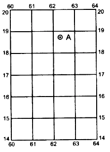
Four-figure grid reference: Square grid or four-figure grid reference e.g., the four figure grid reference of A in the figure is 6218. It means that A lies between Eastings 62 to 63 and Northings 18 to 19.
Six-figure grid reference: The six figure grid reference gives the exact location of a feature. For example, the six figure grid reference of A would be 623188. The first three digits gives the Eastings and the next three digits, the Northings. To get the third digit in the Eastings one has to mentally divide the space between 62 to 63 into 10 equal parts.
Thus, the third digits comes to 3. Similarly to get the sixth digit, mentally divide the space between 18 to 19 into 10 equal parts. Thus, the sixth digit comes to 8. The six-figure grid reference of A is 623188.
The grid squares on the toposheets are generally of 1 sq km..
Sometimes there are squares in which are written QC and QD. These denote two lettered number of 100 square km.

Need a full question paper?

Generate a complete, print-ready paper with questions like this in minutes — across 16+ boards, with answer keys.

Start Generating Free

Similar questions

Explain the effect of accumulation of solid waste on aquatic and terrestrial life.
Study the extract of Survey of India Map Sheet No. $45D/7$ and answer the following questions.
$(a)$ What do you understand by Eastings and Northings?
$(b)$ Give the meaning of each of the following conventional symbols located in the grid square $1622.$
$(i)\ 20r \ (ii)\ PO$
$(c)$ What is the general direction of flow of the Sipu Nadi, given in the map extract? Give one reason to support your answer.
$(d)$ Give the six$-$figure grid reference of:
$(i)$ The point where the canal leaves the earth work, dam market $10r.$
$(ii)$ The spot height $1425$ in the South$-$east corner of the map extract.
$(e)$ Andhra is a better developed settlement than Gulabganj. Give two reasons.
$(f)$ Account for the necessity of ‘fireline’ in the jungle area of the given map extract.
$(g)$
$(i)$ What main purpose is solved by most of the wells in grid square $1621$?
$(ii)$ Why is the water in some of these wells not suitable for drinking?
$(h)$ Name two probable occupations of the people in the settlement of Tokra in squares $2220$ and $2221.$
$(i)$ What is the total length of canal in metres?
$(j)$ Give the angular distance of the temple in Pithapura in $2022$ from Bhumi Margi hill top.
Name the states producing sugar and name the chief centres in each state.
###
Name four sugar milling centres in the northern plains.
On the outline map of India provided:
(a) Draw, name and number the Standard Meridian.
(b) Label the river Yamuna.
(c) Shade and name the Gulf of Khambhat.
(d) Mark and name the Nathu-La Pass.
(e) Mark and name the Karakoram Range.
(f) Shade and name a sparsely populated State in Northeast India.
(g) Shade a region with laterite soil in Eastern India.
(h) Mark with a dot and name Vishakhapatnam.
(i) Mark and name the winds that bring rain to West Bengal in summer.
(j) Print S on the iron mines in Singhbhum.
(a) Mark and name Chennai
What are the problems of the Handloom industry?
The Eastern Coastal Plain and Western Coastal Plain.
On the outline map of India provided:
(a) Draw, name and number the Tropic of Cance
(b) Label the river Narmada
(c) Shade and name Lake Chilka
(d) Mark and name the Aravali Mountains
(e) Mark and name the Karakoram Pass
(f) Shade and name a densely populated state in South India
(g) Shade and name a region with black soil
(h) Mark with a dot and name Srinagar
(i) Mark and name the winds which bring rain in winter to the Coromandel Coast
(j) Name and print O on an oilfield in North-east India.
In the context of the Indian agriculture, answer the following:
How has the consolidation of land holdings helped the farming community?
What are the different types of Soil according to their Zones?
Heavy Industries and Light Industries.