Question
Study the following schematic diagram. It shows the relationship between speed of material and moisture content. Read the index, and answer the following questions.

Image
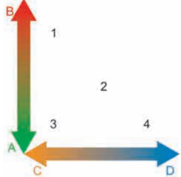
(A) Fast (B) Slow (C) Dry (D) Wet
(1) Creep (2) Slide (3) Fall (4) Flow
(1)What will happen when the weather conditions are dry?
(2)When will a flow occur?
(3)When will a creep occur?
(4)Now can you enumerate the factors which affect mass wasting?

Answer

(1)There will not be moisture content hence speed of material will be low.
(2)Flow will occur when the moisture content as well as speed of material will be high.
(3)Creep will occur when speed of material will be slow.
(4)Factors such as gravity, slope of land, climate of region, amount of water, material and structure of the rock affect mass wasting.

Need a full question paper?

Generate a complete, print-ready paper with questions like this in minutes — across 16+ boards, with answer keys.

Start Generating Free

Similar questions

Have you ever been to a river and seen its bed? Discuss in the class about your observation about the river, its banks, its bed and its velocity.
Describe the Aquatic Biomes.
Explain the Highland or Mountain type climate.
Explain in detail the importance of Indian Ocean to India.
Discuss how development of oceanic tourism should be carried out without disturbing marine life.
A region is having an annual mean temperature of 5° C and an annual rainfall of 1000 mm. Can you comment upon the weathering and the type with the help of following questions?
(1)Which type of weathering will be dominant here?
(2)Where will such a region be found?
What is weathering? Explain different types of weathering.
Given below are a list of measures taken for disaster. Write whether they are pre-disaster or post-disaster and structural or non-structural. Also write the name of the disaster for which they are used. Complete the table.
Sr No.MeasuresPre-disaster / Post- disasterStructural / Non structuralDisaster/ (s) to which they are applicable
1.Conducting mock drills.Pre- disasterNon structuralEarthquake, landslides, fire
2.Discussions about disaster risks and community problems and solutions.………………………………………………
3.Using art, documentaries, music and drama to portray the impact of disasters on communities.………………………………………………
4.Inviting emergency services personnel to provide lectures/demonstrations.………………………………………………
5.Making booklets on disaster related information.………………………………………………
6.Retrofit old buildings.………………………………………………
7.Constructing shelters and evacuation chambers.………………………………………………
8.Making change in land use policy regarding construction of houses in low- lying areas.………………………………………………
9.Constructing buildings and houses using disaster resistant material, design to comply with relevant BIS (Bureau of Indian Standards) codes.………………………………………………
10.Constructing proper drains.………………………………………………
11.Carrying out plantation activities.………………………………………………
12.Regular disaster related activities through radio, TV newspaper, etc.………………………………………………
13.Using satellites for early warning.………………………………………………
14.Evacuation routes in disaster management plans should be delineated.………………………………………………
Which agents of erosion can you see on the cover page of the textbook? Which landforms can you see there? Write the process of formation of any one.
Latitudinal locationWinds and wind systemsProximity to seaContinental locationAltitude
………..………..………..………..………..
………..………..………..………..………..
………..………..………..………..………..