Question
✓
Answer
- (b) $\frac{\pi}{3}$
Explanation:
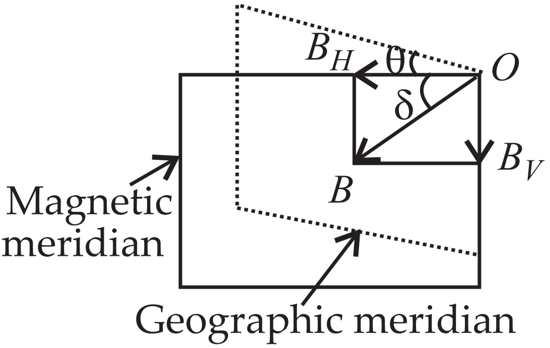
$\tan\theta=\frac{\text{B}_\text{V}}{\text{B}_\text{H}}$ and $\text{B}_\text{H}=\frac{\text{B}_\text{V}}{\sqrt{3}}$
$\therefore\tan\theta=\sqrt{3}\text{ i.e. }\theta=\frac{\pi}{3}$
- (b) Magnetic declination.
Explanation:
The angle between the true geographic north and the north shown by a compass needle is called as magnetic declination or simply declination.
- (d) 90º, 0º
Explanation:
Since angle of dip at a place is defined as the angle $\delta,$ which is the direction of total intensity of earth's magnetic field B makes with a horizontal tine in magnetic meridian,
At poles $\text{B}=\text{B}_\text{V}$ and $\text{B}_\text{V}=\text{B}\sin\delta\therefore\sin\delta=1\Rightarrow\delta=90^\circ$
At equator $\text{B}=\text{B}_\text{H}$ and $\text{B}_\text{H}=\text{B}\cos\delta$
$\therefore\cos\delta=1\Rightarrow\delta=-0^\circ.$
- (a) Will become rigid showing no movement.
Explanation:
A compass needle which is allowed to move in a horizontal plane is taken to a geomagnetic pole. It will stay in any position as the horizontal component of earth's magnetic field becomes zero at the geomagnetic pole.
- (c) Magnetic dip increases as we move away from the equator towards the magnetic pole.
Explanation:
At equator, $\delta=0^\circ$
At poles, $\delta=90^\circ$
$\therefore\delta$ increases as we move from equator towards poles.
Need a full question paper?
Generate a complete, print-ready paper with questions like this in minutes — across 16+ boards, with answer keys.
Explore more
Similar questions
A container contains water upto a height of 20cm and there is a point source at the centre of the bottom of the container. A rubber ring of radius r floats centrally on the water. The ceiling of the room is 2.0m above the water surface.
→- Find the radius of the shadow of the ring formed on the ceiling if r = 15cm.
- Find the maximum value of r for which the shadow of the ring is formed on the ceiling. Refractive index of water $\frac{4}{3}.$
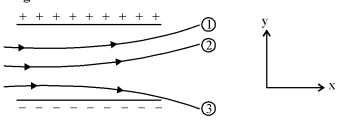
Figure shows track of three charged particles in a uniform elecrostatic field. Give the signs of the three charges. Which particle has the highest charge to mass ratio?
A bird while flying takes a left turn, where does it get the centripetal force from?
The weight Mg of an extended body is generally shown in a diagram to act through the centre of mass. Does it mean that the earth does not attract other particles?
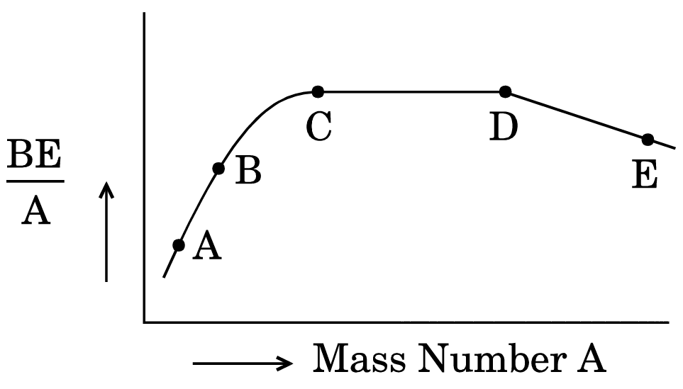
- The figure shows the plot of binding energy (BE) per nucleon as a function of mass number A. The letters A, B, C, D and E represent the positions of typical nuclei on the curve. Point out, giving reasons, the two processes (in terms of A, B, C, D and E), one of which can occur due to nuclear fission and the other due to nuclear fusion.
- Identify the nature of the radioactive radiations emitted in each step of the decay process given below.
$^{A}_{Z}\text{X}\rightarrow ^{A-4}_{Z-2}\text{Y}\rightarrow ^{A-4}_{Z-1}\text{W}$.
What do you mean by coherent sources of light? How are these obtained in the laboratory ?
Bohr's model explains the spectral lines of hydrogen atomic emission spectrum. While the electron of the atom remains in the ground state, its energy is unchanged. When the atom absorbs one or more quanta of energy, the electrons moves from the ground state orbit to an excited state orbit that is further away.
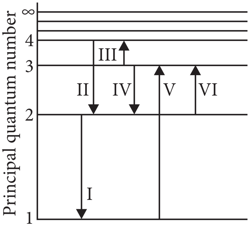
The given figure shows an energy level diagram of the hydrogen atom. Several transitions are marked as I, II, III and so on. The diagram is only indicative and not to scale.
The given figure shows an energy level diagram of the hydrogen atom. Several transitions are marked as I, II, III and so on. The diagram is only indicative and not to scale.
- In which transition is a Balmer series photon absorbed?
- II
- III
- IV
- VI
- The wavelength of the radiation involved in transition II is
- 291nm
- 364nm
- 487nm
- 652nm
- Which transition will occur when a hydrogen atom is irradiated with radiation of wavelength 103nm?
- I
- II
- IV
- V
- The electron in a hydrogen atom makes a transition from n = n1 to n = n2 state. The time period of the electron in the initial state is eight times that in the final state. The possible values of n1 and n2 are.
- n1 = 4,n2 = 2
- n1 = 8,n2 = 2
- n1 = 8,n2 = 3
- n1 = 6,n2 = 2
- The Balmer series for the H-atom can be observed
- If we measure the frequencies of light emitted when an excited atom falls to the ground state.
- If we measure the frequencies of light emitted due to transitions between excited states and the first excited state.
- In any transition in a H-atom.
- None of these.
Indian style of cooling drinking water is to keep it in a pitcher having porous walls. Water comes to the outer surface very slowly and evaporates. Most of energy needed for evaporation is taken from the water itself and the water is cooled down. Assume that a pitcher contains 10kg of water and 0.2g of water comes out per second. Assuming no backward heat transfer from the atmosphere to the water, calculate the time in which the temperature decrease by 5°C. Specific heat capacity of water = 4200J kg-1°C-1 and latent heat of vaporization of water = 2.27 × 10⁶ J kg-1.
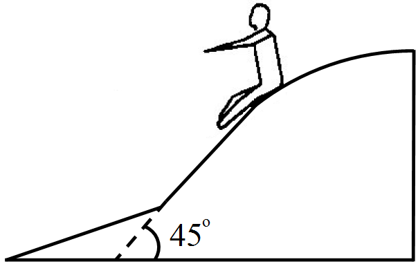
In a children-park an inclined plane is constructed with an angle of incline 45° in the middle part. Find the acceleration of a boy sliding on it if the friction coefficient between the cloth of the boy and the incline is 0.6 and g = 10m/s2.
When the electron orbiting in hydrogen atom in its ground state moves to the third excited state, show how the de Broglie wavelength associated with it would be affected.