Question
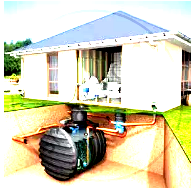
What is a rain water harvester? How does it work?

Answer

It is a storage tank usually fitted underground to your down pipes coming from the roof. Rainwater enters the tank through a filter which removes the leaves and other debris. The system contains a pump which pushes or sucks the rain water back into the house where it is delivered to the toilets or clothes washing machine. The tank is placed in the dark and kept oxygenated to prevent the growth of algae. This filtered untreated water should not be used for drinking.
Rain water harvesters can be installed in houses, bungalows, large sheds or any building with a roof on it to capture the rain water. Commercial premises are very suitable as they often have a larger roof space and higher percentage of water use that can be replaced by rain water.

Need a full question paper?

Generate a complete, print-ready paper with questions like this in minutes — across 16+ boards, with answer keys.

Start Generating Free

Similar questions

Study the extract of the Survey of India Map sheet No. 45D/10 and answer the following questions:
(a) Give the six figure grid reference of:
(i) Triangulated height 217
(ii) A lined well near Chekhla.
(b) 
(i) Name the left bank tributary of the main river.
(ii) State the direction in which this left bank tributary is flowing.
(c) 
(i) Mention a special feature associated with the streams in grid square 9879.
(ii) Name the types of drainage pattern found in grid square 9382.(d) Give the four grid reference of each of the following:
(i) Open scrub
(ii) Bantawada.
(e) Name two relief features that can be seen in grid square 9782 and 9574.
(f) Why do you find limited cultivation in the map extract?
(g) What is the compass direction of Antroli (9576) and Chekhla (9281) from Sangla?
(h) What type of rainfall is experienced in the region shown in the map extract? Justify your answer giving one reason.
(i) Calculate the distance in kilometres along the cart track between Chitrasani (999747) and Pirojpura (978753).
(j) 
(i) What is the geographical name that you would give to the general pattern of settlements in the region shown on the map?
(ii) Name one region shown on the map which is unsuitable for the cultivation of crops.
Name the various types of settlement patterns found on toposheet.
Name the rivers, falling in Arabian Sea and Bay of Bengal.
What are the demerits of canals? How to overcome these defects?
What is the importance of rain water harvesting?
What is ‘October Heat’?
Answer the following questions on the Survey Sheet Number 45 D/7.
(a) Give six figure grid references of the following:
(i) ∆ 364 (ii) The temple at Rampura
(b) Mention any two features seen in the map extract which show that the region has seasonal rainfall
(c) Calculate the distance in kilometres along the cart-track linking Juvol (923826) and Amiwada (944817).
(d) Which is the chief form of irrigation shown in the map extract? Give an evidence to justify your answer.
(e) Give one reason to explain why the streams in grid square 9478 do not join a river. Identify another grid square in the map extract that has similar streams.
(f) What do the following represent:
(i) Black broken lines in 9575 (ii) Black curved lines in 9879.
(g) Identity two landforms shown by the contours in grid square 9876.
(h) (i) What is the general direction of the Balram Nadi?
(ii) Which bank of the main river does the Balram Nadi join?
(i) What is the main occupation of the people living in the area shown in the map extract? Give one reason to support your answer.
|(j) What is meant by scale of a map? What is the scale of the map extract provided to you?
Explain the stages involved in secondary treatment of water.
On the outline map of India provided:
(a) Mark and name Chennai
(b) Label the river Godavari
(c) Shade and label the Chhota Nagpur Plateau
(d) Shade and name the Gulf of Kachchh
(e) Mark and name the Indo-Gangetic Plains
(f) Shade and label an area with Red Soil
(g) Mark and name the winds which bring rain to Mumbai in July and August
(h) Mark and name the Satpura Range
(i) Mark and name the Jharia Coal Field
(j) Shade and label the Northern Circar coastal region
On the outline map of the Indian sub-continent provided to you at the end of this question paper:
(i) Mark with a bold line and label:
(a) The Karakoram Range.
(b) The Eastern Ghats.
(c) The Nilgiris
(ii) Shade and name one region for the : Black soil.
(iii) Mark and label:
(a) The Khyber Pass
(b) The capital city of Assam.
(c) River Godavari.
(iv) (a) Identify, shade and name:
(1) A region of sparse population (less than 50 pp sq.) in North-Eastern India.
(2) A region of ‘Equatorial Forests’.
(b) Mark with one long arrow, the direction of the Summer Monsoon over the Bay of Bengal.