Question
Impact of transportation on distribution of population.
1. Availability of transport facilities is also an important human factor which affect the distribution of population in
2. Roads and railways are two important means of transportation. They increase accessibility to the region and provide facilities for the movement of people goods. Thus, developing trade and generating employment opportunities. Hence, population in such areas increases.
3. For example, density of roads and railways is very high in Uttar Pradesh and therefore it is one of the most densely populated state of India.
4. In some areas due to growth of sea transport, development of port cities and trade takes place. There is also an increase in the transport facilities connecting to the surrounding areas. Therefore, population in coastal areas increases. For example, port cities on eastern and western coastal of India are densely populated.
5. On the other hand, due to lack of transport facilities areas become inaccessible, movement of goods and people become costly and require more time and hence such areas are thinly populated.
Generate a complete, print-ready paper with questions like this in minutes — across 16+ boards, with answer keys.
| A | B | C |
| (1) Climate | (1) Soil | (1) Import food |
| (2) Natural Resources | (2) High density | (2) Woollen products |
| (3) Population | (3) Dry farming | (3) Agriculture |
| (4) Culture | (4) Snow covered area | (4) Kashmiri shawl |
| (5) Israel | (5) Art and craft | (5) Export services for agriculture |

Observe the map and an swer the following questions
(i) Which economic activities are shown in the following map?
(ii) In which region do you don’t find any activity? what could be the reason?
(iii) In which latitudes do you primarily find the distribution of lumbering activity?
(iv) Why is fishing occupation only found in certain areas in the oceans?
(v) Which primary economic activities are mostly found in Europe?
| A | B | C |
| (1) Climate | (1) Skills | (1) Information technology |
| (2) Population | (2) Tropical | (2) Tea, Coffee export |
| (3) Culture | (3) Poor soil | (3) Export oil |
| (4) Gulf countries | (4) Art and craft | (4) Chinese porcelain |
Observe the map and an swer the following questions
(i) What production does the symbol of mining shown in seas and oceans depict?
(ii) In which continent mining is not found?
(iii) In which ocean is the world’s fishing mostly carried out?
(iv) Which primary economic activities are found to the south of Tropic of Capricorn?
(vi) Which primary activity is found in the islands of South East Asia?
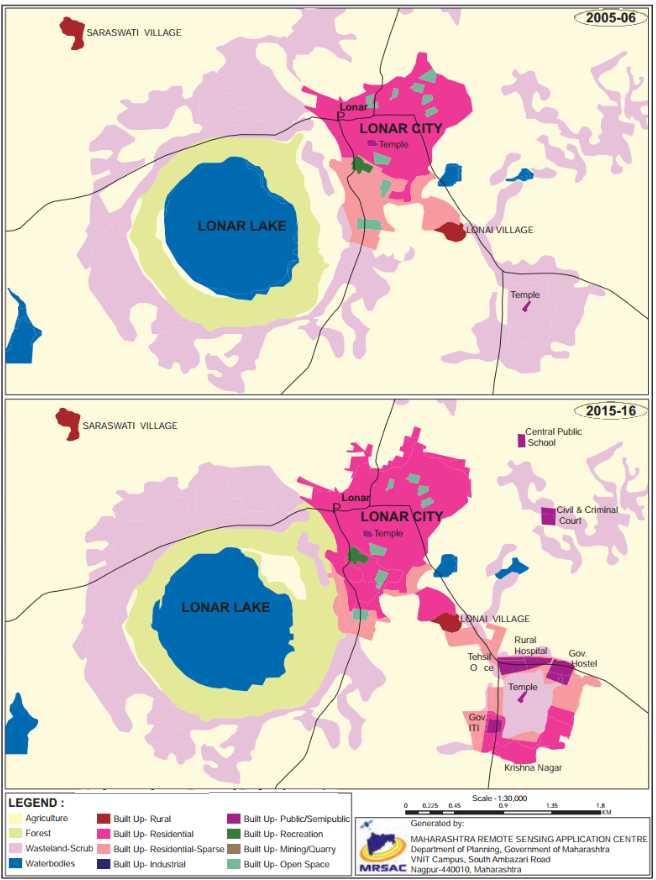
(i) Which periods do the map belongs to?
(ii) Which land covers have reduced? What are their colours?
(iii)Which landcovers seen to have increased? what are their colours?
(iv) Which land cover has been replaced by increased landcovers?
(vi) Write a conclusive note comparing both the maps.