Question
Population characteristics in Stage 4 and Stage 5 in Demographic Transition Theory.
| Stage 4 | Stage 5 |
| (i) Improvement in the economic status of the citizens. | (i) High economic status of the citizens of the country. |
| (ii) Secondary and tertiary occupations have higher share than primary occupations. | (ii) Tertiary occupation contribute most towards the economy. |
| (iii) Population growth is almost minimal. | (iii) Population may reduce because of lower birth rate than death rate. |
| (iv) USA is passing through this stage. | (iv) Sweden and Finland population are in this stage. |
Generate a complete, print-ready paper with questions like this in minutes — across 16+ boards, with answer keys.
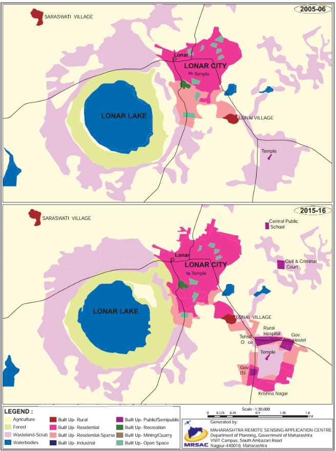
(i) Which periods do the map belongs to?
(ii) Which land covers have reduced? What are their colours?
(iii)Which landcovers seen to have increased? what are their colours?
(iv) Which land cover has been replaced by increased landcovers?
(vi) Write a conclusive note comparing both the maps.
| A | B | C |
| (1) Climate | (1) Soil | (1) Import food |
| (2) Natural Resources | (2) High density | (2) Woollen products |
| (3) Population | (3) Dry farming | (3) Agriculture |
| (4) Culture | (4) Snow covered area | (4) Kashmiri shawl |
| (5) Israel | (5) Art and craft | (5) Export services for agriculture |
(i) Enlist the colours used for showing land uses in the index.
(ii) What do the blue and black lines show?
(iii) What is the name of the river in the map?
(iv) Name any two villages shown on the map.
(v) Which city is shown on the map?

| A | B | C |
| (1) Climate | (1) Skills | (1) Information technology |
| (2) Population | (2) Tropical | (2) Tea, Coffee export |
| (3) Culture | (3) Poor soil | (3) Export oil |
| (4) Gulf countries | (4) Art and craft | (4) Chinese porcelain |