Question
Study the given map in fig and answer the following questions.Image
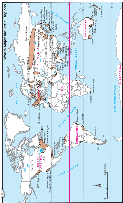
(i) In which hemisphere do you find more concentration of industries?
(ii) In which part of North America has the industrial region been mainly developed?
(iii) In which part of Europe is concentration of industries mainly found?
(iv) Why is less industrial development found in other parts of African continent except coastal areas?
(v) In which part of India do you find concentration of industries?
(vi) Why do you think coastal areas have higher concentration industries?
(vii) Write a concluding paragraph on latitudinal distribution of industries in the world.

Answer

(i) Northern Hemisphere.
(ii) North eastern Region.
(iii) North western, South and Central part
(iv) Dense forest, deserts, mountains, grasslands in other parts of African continent are responsible for less development of industries.
(v) Portal cities like Mumbai, Chennai, Kolkata and other areas like Delhi, Bangalore, Chota Nagpur etc.

(vi) Coastal areas have better ports and inland water transport facilities. Even road and rail transport are well developed.

  • Extensive level land.
  • Industries which depend on imported raw material like oil prefer to develop on coastal areas.
  • Industries which need humid climate develop in coastal areas for example textile industry.

(vii) Major industrial regions are concentrated in Northern Hemisphere in the latitudinal belt of 30° North to 50° North latitudes. However, there is an exception of Siberian industrial region in Russia.

  • North America, major European countries, Japan, China and parts of Russia falls in this latitudinal belt.
  • Major cause of the development of industries in this latitudinal belt is the Industrial Revolution in Europe.
  • In this region both mineral based and agro-based industries have developed.
  • Development of science and technology, skilled labour, well developed transportation facilities, high standard of living and extensive local market in this latitudinal belt are the other factors responsible for the development of industries.
  • However, outside this major industrial belt in Northern Hemisphere* only exception is India, industries have developed in latitudinal belt 8° North to 20° North.
  • Even in Southern Hemisphere industries have developed in the same latitudinal belt i.e. 30° South to 50° South latitudinal belt in South Africa, South America and South Australia.

Need a full question paper?

Generate a complete, print-ready paper with questions like this in minutes — across 16+ boards, with answer keys.

Start Generating Free

Similar questions

See map of Ichalkaranji city and observe how changes have occurred in the city over the years. Answer the questions that follow.

Image


(i) Enlist the colours used for showing land uses in the index.
(ii) What do the blue and black lines show?
(iii) What is the name of the river in the map?
(iv) Name any two villages shown on the map.
(v) Which city is shown on the map?

Explain the human factors affecting distribution of population.

Image
(1)Which means of transportation are shown in the map?
(2)Between which continents do you see an overall higher flow of transportation?
(3)Which canals can you see in their waterways? What can be the purpose?
(4)Which two major cities in India are connected internationally through airways?
(5)Which two continents show lesser use of air routes? Why?
Age structure affects economy of the country.
Population characteristics in Stage 1 and Stage 2 in Demographic Transition theory
Early expanding stage and Late expanding stage
See map of Ichalkaranji city and observe how changes have occurred in the city over the years. Answer the questions that follow.

Image

(i) Which periods do the map belongs to?
(ii) Which land covers have reduced? What are their colours?
(iii)Which landcovers seen to have increased? what are their colours?
(iv) Which land cover has been replaced by increased landcovers?
(vi) Write a conclusive note comparing both the maps.


Image

Observe the map and an swer the following questions

(i) What production does the symbol of mining shown in seas and oceans depict?
(ii) In which continent mining is not found?
(iii) In which ocean is the world’s fishing mostly carried out?
(iv) Which primary economic activities are found to the south of Tropic of Capricorn?
(vi) Which primary activity is found in the islands of South East Asia?

Causes of migration
Population composition and Population structure