Question
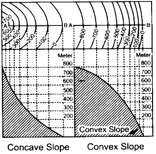
 What is Concave Slope and Convex Slope? Explain?

Answer

Concave Slope: The slope is very gentle at the foot and it goes on getting steeper and steeper towards the top. The spacing between successive contours at the lower level is more than at the higher level.

Convex Slope: The slope is very steep at the foot and it goes on becoming gentle towards the top. The contour lines are therefore, unequally spaced but there is a sequence, which is just the opposite of a concave slope diagram. The spacing between successive contours at the lower level is less than at
the higher level.

Need a full question paper?

Generate a complete, print-ready paper with questions like this in minutes — across 16+ boards, with answer keys.

Start Generating Free

Similar questions

On the outline map of India provided:
(a) Mark and name Kochi.
(b) Label the river Krishna.
(c) Shade and label the Malwa Plateau.
(d) Mark and label the Konkan Coast.
(e) Shade and label the Gulf of Mannar.
(f) Shade and label an alluvial soil area in Peninsular India.
(g) Mark with arrows the direction of the Arabian Sea branch of South West Monsoon Winds.
(h) Shade and label the Western Ghats.
(i) Mark the Jharia coal field.
(j) Shade and name a densely populated area.
What is a rain water harvester? How does it work?
Mention the important features of a river valley.
Show the different drainage patterns.
(i) What is the importance of a Relief Map.
(ii) How can we show occupations by the evidences of names or by inference of relief features?
Study the extract of the Survey of India Map sheet No. 45D/10 and answer the following questions:
(a) 
(i) Give the four figure grid reference of the settlement of Hamirpura.
(ii) Give the six figure grid reference of the temple in the settlement of Jolpur.
(b) 
(i) What does the blue coloured circle in the grid square 0619 represent?
(ii) What is the compass direction of Dantrai from Jolpur?
(c) What is the difference between the:
(i) Pattern of settlements in 0725 and the settlement of Idarla?
(ii) Drainage pattern of the streams in 0624 and those in 0824?
(d) 
(i) What is the value of the contour line in square 0226?
(ii) What is the contour interval in the map?
(e) Mention any two factors which provide evidence that the region in the map extract is a rural region.
(f) 
(i) How does the feature, indicated by the black curves in 0721, show that rainfall in this region is seasonal?
(ii) Mention one man-made feature in the map which also provides evidence that the rainfall is seasonal.
(g)
(i) Name two natural features in 0527.
(ii) Name two manmade features in 0325.
(h) Name two features which make Dantrai a more important settlement than the other settlements in the map extract.
(i) Calculate the area of the region which lies to the south of northing 21 in square kilometres.
(j)  What are the following?
(i) The black vertical line between eastings 09 and 10.
(ii) 302 in grid square 0425.
Explain Why is it so important to recycle?
(i) On a topographical map two stations A and B are situated at height of 500 metres and 100 metres respectively. If the horizontal distance between them is 2 km, calculate the gradient.
(ii) On a topographical map, two places A and B are given. Calculate the gradient between them.
Mention any three water harvesting systems practised in India.
How the compass direction of an object, feature or place given from the given point?